IMAGES TAKEN NEAR TO
Manor Brow, KESWICK, CA12 4BD
Introduction
This page details the photographs taken nearby to Manor Brow, CA12 4BD by members of the Geograph project.
The Geograph project started in 2005 with the aim of publishing, organising and preserving representative images for every square kilometre of Great Britain, Ireland and the Isle of Man.

There are currently over 7.5m images from over14,400 individuals and you can help contribute to the project by visiting https://www.geograph.org.uk
Image Map
Images are licensed for reuse under creativecommons.org/licenses/by-sa/2.0
Notes
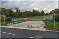
- Clicking on the map will re-center to the selected point.
- The higher the marker number, the further away the image location is from the centre of the postcode.
Image Listing (29 Images Found)
Images are licensed for reuse under creativecommons.org/licenses/by-sa/2.0
Image
Details
Distance
1
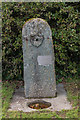
Drinking Fountain
Drinking Fountain at the top of Manor Brow.
The plaque reads:
Samuel Ladyman
Drinking Water Fountain
One of four erected circa 1875
Cleaned and marked by Keswick Civic Society 2003"
Samuel Ladyman was a local businessman and philanthropist in the 19th Century, who as well as the water fountains provided various seats in the area and also funded a winter soup kitchen.
For a photo showing where it is sited, see Image
Image: © Ian Capper
Taken: 24 Sep 2018
0.01 miles
2
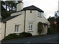
Tollhouse by the A591, Chestnut Hill, Keswick
Tollhouse by the A591, in the parish of Keswick (Allerdale District), Toll Bar Cottage, Chestnut Hill junction with Manor Brow, CA12 4LT.
Grade II listed.
List Entry Number: 1327117 https://historicengland.org.uk/listing/the-list/list-entry/1327117
To be surveyed
Milestone Society National ID: CB.KES02
Image: © Milestone Society
Taken: Unknown
0.02 miles
3
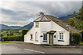
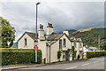
Toll Bar Cottage
Late 18th Century toll house on Chestnut Hill by its junction with Manor Brow. Grade II listed - see www.historicengland.org.uk/listing/the-list/list-entry/1327117.
On the far left of the photo can be the drinking fountain in Image
In the distance is Bassenthwaite Lake.
Image: © Ian Capper
Taken: 24 Sep 2018
0.02 miles
4
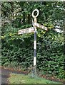
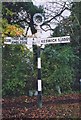
Direction Sign – Signpost on the A591 Castlerigg Brow, Keswick
Located on the southwest side of the junction of the A591 Castlerigg Brow. Manor Brow and Chestnut Hill in Keswick parish. 3 arms and annulus finial. See also https://www.geograph.org.uk/photo/6098989.
Milestone Society National ID: CU_NY2723
Image: © B Todd
Taken: 18 Sep 2023
0.03 miles
5
Direction Sign - Signpost by the A591, Castlerigg Brow, Keswick
Annulus finial - 3 arms; Cumberland CC halo by the A591, in parish of Keswick (Allerdale District), Castlerigg Brow junction with Manor Brow and Chestnut Hill. See also https://www.geograph.org.uk/photo/7600141.
Surveyed
Milestone Society National ID: CU_NY2723
Image: © Milestone Society
Taken: 1 Jan 2007
0.03 miles
6
Castlerigg Cottage
Cottage on Chestnut Hill shown on the 1864 1:2,500 map.
Image: © Ian Capper
Taken: 24 Sep 2018
0.04 miles
7
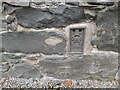
Ordnance Survey Flush Bracket (S9566) & Cut Mark
The OS cut mark & Flush Bracket can be found on the east angle of the Grange Hotel, Ambleside Road. The FB marks a point 131.017m and the cut mark marks a point 130.804m above mean sea level.
Image: © Adrian Dust
Taken: 14 Sep 2022
0.09 miles
8
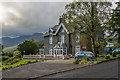
The Grange
Victorian house on Manor Brow, marked on the 1864 1:2,500 map as Larch House, on the 1899 edition as The Larches and the 1968 edition as The Grange Hotel. Now marketed as The Grange Country House. In the background is Skiddaw.
Image: © Ian Capper
Taken: 24 Sep 2018
0.10 miles
9
West Cumbria Water Supplies Project
Access Point 07 on Chestnut Hill to United Utilities' West Cumbria Water Supplies Project, laying a new pipeline which will result in West Cumbria being supplied with water from Thirlmere in place of Ennerdale Water, the licence for abstraction from which will expire in 2022.
Image: © Ian Capper
Taken: 24 Sep 2018
0.10 miles
10
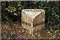
Old Milepost by the A591, Keswick
Cast iron post by the A591, in parish of KESWICK (ALLERDALE District), Castlerigg, against wall in pavement. Ambleside casting, erected by the Ambleside turnpike trust in the 19th century.
Inscription reads:-
: KESWICK / 1 MILE : : CASTLERIGG : : AMBLESIDE / 15 / MILES / W_MERE/ 20 / MILES :
Milestone Society National ID: CU_KWWM01.
Image: © CF Smith
Taken: 11 May 2009
0.11 miles