IMAGES TAKEN NEAR TO
KESWICK, CA12 4AJ
Introduction
This page details the photographs taken nearby to CA12 4AJ by members of the Geograph project.
The Geograph project started in 2005 with the aim of publishing, organising and preserving representative images for every square kilometre of Great Britain, Ireland and the Isle of Man.

There are currently over 7.5m images from over14,400 individuals and you can help contribute to the project by visiting https://www.geograph.org.uk
Image Map
Images are licensed for reuse under creativecommons.org/licenses/by-sa/2.0
Notes
- Clicking on the map will re-center to the selected point.
- The higher the marker number, the further away the image location is from the centre of the postcode.
Image Listing (29 Images Found)
Images are licensed for reuse under creativecommons.org/licenses/by-sa/2.0
Image
Details
Distance
1
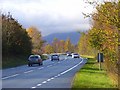
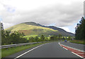
The A66 near Keswick
Part of the trunk route that links Workington on the west coast with Scotch Corner on the A1. The road here was upgraded during the 1960s. The previous route is just to the south. Before the upgrading the road west of Penrith had been the A594.
Image: © Andrew Smith
Taken: 31 Oct 2008
0.01 miles
2
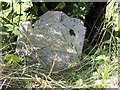
Old Milestone by the former A66, near Storms Farm
Stone post (plate lost) by the UC road (was A66), in parish of ST JOHNS CASTLERIGG AND WYTHBURN (ALLERDALE District), Storms Farm, under hedge back of on grass verge by new stone, on North side of road. Keswick iron plate, erected by the Keswick turnpike trust in the 19th century.
Inscription once read:-
(PENRITH)
(16 MILES)
(KESWICK)
(2 MILES)
Milestone Society National ID: CU_PRKW16.
Image: © CF Smith
Taken: 25 Aug 2005
0.08 miles
3
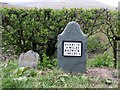
New Milestone by the former A66, near Storms Farm
Metal plate attached to new stone post by the UC road (was A66), in parish of ST JOHNS CASTLERIGG AND WYTHBURN (ALLERDALE District), Storms Farm, on grass verge by old stone, on North side of road. Keswick iron plate, erected by the Keswick turnpike trust in the 20th century.
Inscription reads:-
PENRITH
16 MILES
KESWICK
2 MILES {small arrow} :
Milestone Society National ID: CU_PRKW16R.
Image: © CF Smith
Taken: 2 Dec 2009
0.09 miles
5
Keswick Railway Cyclepath
One of many bridges over the River Greta
Image: © Mick Garratt
Taken: 16 Jul 2005
0.14 miles
6
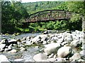
White Moss Bridge
White Moss Bridge is one of a number of bridges over the River Greta along the line of the former Cockermouth, Keswick and Penrith Railway. After the closure of the line in 1972, the section from Keswick to Threlkeld was converted into a popular path for walkers and cyclists.
Three of the bridges, including this one, were destroyed in Storm Desmond in 2015 and as a result the path was closed for a considerable time. This bridge, a completely new structure, was installed in March 2020 when the path was reopened.
Image: © Oliver Dixon
Taken: 6 Sep 2021
0.19 miles
7
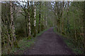
Section of cycle path approaching the missing bridge
Image: © Robert Eva
Taken: 12 Apr 2017
0.19 miles
8
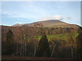
Birches above the Greta
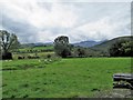
Looking over the River Greta towards Lonscale Fell and Skiddaw Little Man.
Image: © Karl and Ali
Taken: 13 Nov 2011
0.19 miles
10
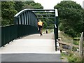
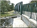
White Moss Bridge
White Moss Bridge is one of a number of bridges over the River Greta along the line of the former Cockermouth, Keswick and Penrith Railway. After the closure of the line in 1972, the section from Keswick to Threlkeld was converted into a popular path for walkers and cyclists.
Three of the bridges, including this one, were destroyed in Storm Desmond in 2015 and as a result the path was closed for a considerable time. This bridge, a completely new structure, was installed in March 2020 when the path was reopened.
Image: © Oliver Dixon
Taken: 6 Sep 2021
0.20 miles