IMAGES TAKEN NEAR TO
King Street, CARLISLE, CA1 1SJ
Introduction
This page details the photographs taken nearby to King Street, CA1 1SJ by members of the Geograph project.
The Geograph project started in 2005 with the aim of publishing, organising and preserving representative images for every square kilometre of Great Britain, Ireland and the Isle of Man.

There are currently over 7.5m images from over14,400 individuals and you can help contribute to the project by visiting https://www.geograph.org.uk
Image Map
Images are licensed for reuse under creativecommons.org/licenses/by-sa/2.0
Notes
- Clicking on the map will re-center to the selected point.
- The higher the marker number, the further away the image location is from the centre of the postcode.
Image Listing (534 Images Found)
Images are licensed for reuse under creativecommons.org/licenses/by-sa/2.0
Image
Details
Distance
1
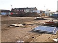
William Street Car Park, closed for redevelopment
Preparations underway for construction of a new office building, to face onto Botchergate. The work was completed in autumn 2016 - see Image .
Archaeological excavations on the site revealed a Roman cemetery, from which many artefacts were recovered - see Cumberland News http://www.cumberlandnews.co.uk/news/Roman-artefacts-found-on-site-of-new-council-HQ-in-Carlisle-6efa639e-9a48-4fb2-9fa2-04c6d254b13c-ds .
Image: © Rose and Trev Clough
Taken: 5 Feb 2015
0.01 miles
2
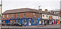
Lower Botchergate, Carlisle - June 2017 (1)
The south-west side of Botchergate from Princess Street to King Street. Built between 1828 and 1836, this row once contained the "Queen Adelaide" pub, which is thought to have been the second building from the left - see: Image] .
Photograph is for record only - I have no connection with any business seen in this view and cannot advise on their products or services.
Image: © The Carlisle Kid
Taken: 14 Jun 2017
0.04 miles
3
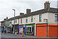
Lower Botchergate, Carlisle - June 2017 (2)
For information on these buildings, see: Image] .
Image: © The Carlisle Kid
Taken: 14 Jun 2017
0.04 miles
4
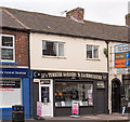
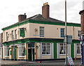
Former "Queen Adelaide" pub, Botchergate - June 2017
Also known as the "Queen Victoria Inn" and simply "Queen Inn", these premises were built between 1822 and 1836 and known as the "Queen Adelaide" until circa 1858. Two period photographs of the pub are known to exist, one from 1904 and another dated 1931 with the name "Queen Adelaide" clearly visible together with the then publican, Mrs M Ruell and her daughter. This 1931 view suggests the "Queen Adelaide" was approximately half the building shown here - left from the door now marked "No. 142".
The pub was acquired by the State Management Scheme on 5 August 1916 (when it was owned by Carlisle New Brewery Co Ltd) and closed in 1935 on opening of the rebuilt "Earl Grey", which is almost opposite - see: Image] .
The original Purchase Order recently (June 2017) appeared for sale on E-Bay and confirms the address as 142 Botchergate.
Photograph is for record only - I have no connection with any business seen in this view and cannot advise on their products or services.
Image: © The Carlisle Kid
Taken: 14 Jun 2017
0.04 miles
5
Building on SW side of Lancaster Street
Ordnance Survey documents indicate that a benchmark levelled at 20.367m above Newlyn Datum was verified in 1972 on a corner of a building at this location
Image: © Luke Shaw
Taken: 19 Aug 2019
0.05 miles
6
Former "Golden Lion", St Nicholas Street - September 2016 (1)
Built in the mid-19th Century, the Golden Lion was State managed from September 1916 until 1973. Renamed "Gallagher's" in recent years, it now has an "Irish" theme.
See also: Image] .
Photograph is for record only - I have no connection with this business and cannot advise on its products or services.
Image: © The Carlisle Kid
Taken: 20 Sep 2016
0.05 miles
7
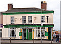
Former "Golden Lion", St Nicholas Street - September 2016 (2)
Another view of what is now "Gallagher's Irish pub".
For the story of this building, see: Image] .
Image: © The Carlisle Kid
Taken: 20 Sep 2016
0.05 miles
8
The Golden Lion, St Nicholas Street, Carlisle
Image: © Alexander P Kapp
Taken: 17 Jul 2008
0.05 miles
9
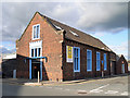
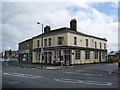
The Old Reading Room
This was the Lord Street Working Men's Reading Room, built in 1851 to provide larger premises for a popular reading room which had been running in John Street, Botchergate since 1848. At one time there were 300 members, using the lending library and attending classes and discussion groups. The new building was made possible by donations of money and services from middle class benefactors, and rule changes soon followed, including a ban on controversial political and religious material. The working class members felt alienated and stopped coming - by 1863 the reading room was hardly used.
Information from J. Rose (see Google Books http://books.google.co.uk/books/about/The_Intellectual_Life_of_the_British_Wor.html?id=3B-qbvQTYyEC&redir_esc=y ) and A. Fraser http://capping.slis.ualberta.ca/cap03/andrew/capping.htm .
Today the building is occupied by Border City Windows, the front door is on Lancaster Street with Lord Street to the right.
Image: © Rose and Trev Clough
Taken: 14 Sep 2013
0.05 miles
10
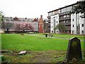
Park on site of former church
Christ Church once stood here, the fairly substantial building had a tower with a spire, which appears in this photo c.1910 http://photos1.blogger.com/blogger/5650/2232/1600/c6.18.jpg (from "Carlisle Postcards" blog http://carlislepostcards.blogspot.com/ ). The church was consecrated in 1830 and demolished in 1953. There are still a few headstones around the sides of the park. Another view from Botchergate here Image .
The block of flats on the right is called The Picture House, built on the site of the disused Palace Cinema which was destroyed by fire in 2004.
Image: © Rose and Trev Clough
Taken: 23 Apr 2011
0.05 miles