IMAGES TAKEN NEAR TO
The Crescent, CARLISLE, CA1 1QW
Introduction
This page details the photographs taken nearby to The Crescent, CA1 1QW by members of the Geograph project.
The Geograph project started in 2005 with the aim of publishing, organising and preserving representative images for every square kilometre of Great Britain, Ireland and the Isle of Man.

There are currently over 7.5m images from over14,400 individuals and you can help contribute to the project by visiting https://www.geograph.org.uk
Image Map
Images are licensed for reuse under creativecommons.org/licenses/by-sa/2.0
Notes
- Clicking on the map will re-center to the selected point.
- The higher the marker number, the further away the image location is from the centre of the postcode.
Image Listing (1201 Images Found)
Images are licensed for reuse under creativecommons.org/licenses/by-sa/2.0
Image
Details
Distance
1
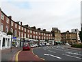
The Crescent, Carlisle
Several takeaways and cafe-bars on this street, which curves round towards the railway station (out of view past the traffic lights on the far right). Behind the lights is the Griffin pub Image
Image: © Rose and Trev Clough
Taken: 7 Sep 2008
0.00 miles
3
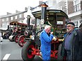
Steam engines on The Crescent
Not something you'd expect to see on a Saturday evening up the town.
There was a steam rally over the weekend at a local park http://www.bordercitysteamfair.co.uk/ . The selection of vintage vehicles assembled here was probably to publicise the event - though they may have just popped out for some fish and chips.
What the street looks like on a quiet day - Image .
Image: © Rose and Trev Clough
Taken: 2 Jun 2012
0.01 miles
4
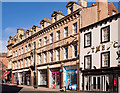
Former "Red Lion Hotel" - March 2018 (1)
Botchergate view of the former "Red Lion Hotel", now the County Hotel. For information on this building, see; Image] .
See also: Image] and Image] .
Photograph is for record only – I have no connection with any business seen in this view and cannot advise on their products or services.
Image: © The Carlisle Kid
Taken: 9 Mar 2018
0.01 miles
5
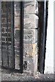
Benchmark at gated entrance, #4 The Crescent
Ordnance Survey cut mark benchmark described on the Bench Mark Database at http://www.bench-marks.org.uk/bm38328
There is a wider view at Image
Image: © Roger Templeman
Taken: 18 Jun 2011
0.01 miles
6
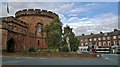
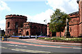
The Citadel and The Crescent, Carlisle.
The statue is to William, Earl of Lonsdale K.G. Lord Lieutenant of Cumberland and Westmoreland 1802-44. Note the e in more. Before Westmorland was absorbed into Cumbria in 1972 it had lost that e, but that was a common alternative spelling in the 1700s and early 1800s, and has transferred to the USA where it is considered correct.
More about the two towers, this is the eastern tower, at; http://www.visitcumbria.com/car/carlisle-citadel/
Image: © Chris Morgan
Taken: 17 Oct 2014
0.01 miles
7
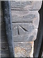
Ordnance Survey Cut Mark
This OS cut mark can be found on the Archway on The Crescent. It marks a point 24.381m above mean sea level.
Image: © Adrian Dust
Taken: 12 Apr 2016
0.01 miles
8
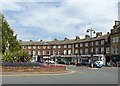
The Crescent, Carlisle
The curved frontage complements the circular eastern tower of the Citadel. Built in stages between c.1820-24, those to the right being originally 2 storeys, but raised to 3 storeys towards the end of the 19th century. Listed Grade II.
This location is also the end of the A7 on its journey from Edinburgh.
Image: © Alan Murray-Rust
Taken: 8 Jul 2018
0.01 miles
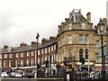
10
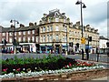
The County Hotel
At the corner of The Crescent (left) and Botchergate (right). Originally called the Red Lion, the hotel was completed in 1896 http://www.imagesofengland.org.uk/details/default.aspx?id=386630 .Bar Solo (painted turquoise) at the front of the building has some interesting Victorian tilework inside.
Image: © Rose and Trev Clough
Taken: 3 Aug 2008
0.02 miles