IMAGES TAKEN NEAR TO
Warwick Road, CARLISLE, CA1 1LU
Introduction
This page details the photographs taken nearby to Warwick Road, CA1 1LU by members of the Geograph project.
The Geograph project started in 2005 with the aim of publishing, organising and preserving representative images for every square kilometre of Great Britain, Ireland and the Isle of Man.

There are currently over 7.5m images from over14,400 individuals and you can help contribute to the project by visiting https://www.geograph.org.uk
Image Map
Images are licensed for reuse under creativecommons.org/licenses/by-sa/2.0
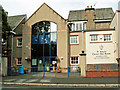
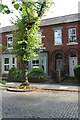
Notes
- Clicking on the map will re-center to the selected point.
- The higher the marker number, the further away the image location is from the centre of the postcode.
Image Listing (86 Images Found)
Images are licensed for reuse under creativecommons.org/licenses/by-sa/2.0
Image
Details
Distance
1
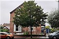
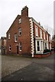
Nos. 124 Rokeby Villa and 122 Waverley Villa
Three is an Ordnance Survey benchmark Image at the road end of the party wall between the front gardens of the two houses
Image: © Roger Templeman
Taken: 30 Jul 2021
0.02 miles
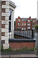
2
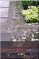
Benchmark on front wall of Rokeby Villa, #124 Warwick Road
Ordnance Survey rivet benchmark described on the Bench Mark Database at http://www.bench-marks.org.uk/bm38340
Image: © Roger Templeman
Taken: 18 Jun 2011
0.03 miles
3
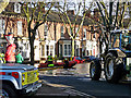
Launching a rescue boat in Warwick Road
Rescue teams from up and down the country came to assist the local emergency services, following severe flooding in Carlisle overnight.
Image: © Rose and Trev Clough
Taken: 6 Dec 2015
0.04 miles
4
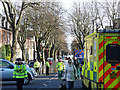
Warwick Road - no access except by boat
Overnight flooding turned this road into a river.
Image: © Rose and Trev Clough
Taken: 6 Dec 2015
0.05 miles
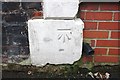
5
No. 1 Lismore Place
There is an OS benchmark Image on the base white quoin on the near corner of the house
Image: © Luke Shaw
Taken: 16 Nov 2019
0.06 miles
6
Benchmark on #1 Lismore Place and Houses of Lismore Street
The Ordnance Survey cut mark benchmark is described on the Bench Mark Database at http://www.bench-marks.org.uk/bm38337
Image: © Roger Templeman
Taken: 18 Jun 2011
0.06 miles
7
Benchmark on #1 Lismore Place
Ordnance Survey cut mark benchmark described on the Bench Mark Database at www.bench-marks.org.uk/bm38337. There is another image showing the mark at Image
Image: © Luke Shaw
Taken: 16 Nov 2019
0.06 miles
8
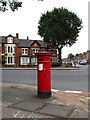
VR Pillar Box, Carlisle
On the corner of Warwick Road and Lismore Place.
Image: © David Rogers
Taken: 18 Sep 2009
0.07 miles
9
St Aidan's County High School (2008)
Entrance in Lismore Place. The sign says it is a foundation school and specialist sports college.
Some of the buildings date from 1909, originally being occupied by the Carlisle and County High School for Girls. This was closed in 1970, when St Aidan's was established as a mixed comprehensive secondary school.
In 2008 St Aidan's was merged with North Cumbria Technology College (formerly Harraby Secondary School) to create The Richard Rose Central Academy.
St Aidan's School was demolished in 2009. A new school was built on the site https://www.geograph.org.uk/photo/5904931 and the academy moved here from temporary accommodation at Harraby in January 2011.
Image: © Rose and Trev Clough
Taken: 5 Jul 2008
0.08 miles
10
No. 38 Broad Street
Ordnance Survey records indicate that a benchmark levelled at 16.164m above Newlyn Datum was verified low down on the wall then fronting the house in 1972. See www.bench-marks.org.uk/bm102846
Image: © Luke Shaw
Taken: 24 Aug 2019
0.09 miles