IMAGES TAKEN NEAR TO
St. Aidans Road, CARLISLE, CA1 1LS
Introduction
This page details the photographs taken nearby to St. Aidans Road, CA1 1LS by members of the Geograph project.
The Geograph project started in 2005 with the aim of publishing, organising and preserving representative images for every square kilometre of Great Britain, Ireland and the Isle of Man.

There are currently over 7.5m images from over14,400 individuals and you can help contribute to the project by visiting https://www.geograph.org.uk
Image Map
Images are licensed for reuse under creativecommons.org/licenses/by-sa/2.0
Notes
- Clicking on the map will re-center to the selected point.
- The higher the marker number, the further away the image location is from the centre of the postcode.
Image Listing (69 Images Found)
Images are licensed for reuse under creativecommons.org/licenses/by-sa/2.0
Image
Details
Distance
1
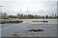
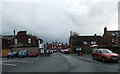
Trapped flood water, Carlisle Rugby Club
The ground is off Warwick Road, in an area of Carlisle hit by serious flooding on 6 December 2015. At the height of the flood, the water level was just below the goal crossbar (as seen in photos on the Rugby Club website http://www.pitchero.com/clubs/carlislerugby ).
The rivers Petteril and Eden overtopped nearby flood banks, which then prevented the water from flowing back. A few days later the site was drained by putting relief channels in the defences, and deployment of pumps.
Image: © Rose and Trev Clough
Taken: 9 Dec 2015
0.09 miles
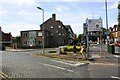
3
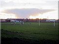
Playing fields off St Aidan's Road, Carlisle
Playing fields located adjacent to St Aidan's Road, Carlisle.
Image: © Graham Robson
Taken: 3 Nov 2013
0.12 miles
5
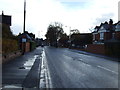
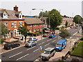
Warwick Road, Carlisle
The flower bed is at the junction of Warwick Road and St Aidans Road, with Petteril Street opposite. This stretch of Warwick Road is lined with guest houses.
Image: © Lis Burke
Taken: 27 Sep 2008
0.14 miles
6
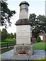
Lawson drinking fountain, Stony Holme
Located beside Image . The fountain (originally with a lamp on top) used to be in Court Square, near the station cab rank. It had to be moved in about 1930 when the underground toilets were built in its place (information from Carlisle Encyclopaedia http://www.carlisleshistory.co.uk/page49.htm ).
Inscription : Presented by Wilfrid Lawson Esqr. M.P. to the citizens of Carlisle. November 1861.
Sir Wilfrid Lawson, 2nd Baronet of Brayton, was a Liberal Party politician and prominent temperance campaigner : http://en.wikipedia.org/wiki/Sir_Wilfrid_Lawson,_2nd_Baronet,_of_Brayton .
Image: © Rose and Trev Clough
Taken: 14 Aug 2011
0.14 miles
8
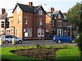
Warwick Road, Carlisle
The floodlights of Brunton Park are visible above the roofline on the North side of the street.
Image: © Clive Nicholson
Taken: 3 Jul 2006
0.15 miles
9
Triangle at junction of Eldred Street and Warwick Road
Image: © Luke Shaw
Taken: 24 Aug 2019
0.15 miles