IMAGES TAKEN NEAR TO
Warwick Road, CARLISLE, CA1 1JY
Introduction
This page details the photographs taken nearby to Warwick Road, CA1 1JY by members of the Geograph project.
The Geograph project started in 2005 with the aim of publishing, organising and preserving representative images for every square kilometre of Great Britain, Ireland and the Isle of Man.

There are currently over 7.5m images from over14,400 individuals and you can help contribute to the project by visiting https://www.geograph.org.uk
Image Map
Images are licensed for reuse under creativecommons.org/licenses/by-sa/2.0
Notes
- Clicking on the map will re-center to the selected point.
- The higher the marker number, the further away the image location is from the centre of the postcode.
Image Listing (151 Images Found)
Images are licensed for reuse under creativecommons.org/licenses/by-sa/2.0
Image
Details
Distance
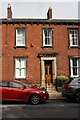
1
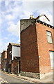
Houses on Hartington Place
There is an OS benchmark Image on the step at the first doorway along the alley
Image: © Luke Shaw
Taken: 5 Jul 2018
0.01 miles
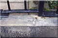
2
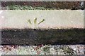
Benchmark on step of #2 Hartington Place
Ordnance Survey pivot benchmark described on the Bench Mark Database at www.bench-marks.org.uk/bm95177. It appears that the step has been rotated after the mark was cut.
Image: © Luke Shaw
Taken: 5 Jul 2018
0.02 miles
3
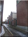
Alley behind Warwick Road, Carlisle
Image: © Jonathan Thacker
Taken: 25 Nov 2010
0.02 miles
4
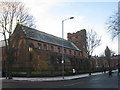
Our Lady and St. Joseph, Carlisle
Built 1891-3.
Image: © Jonathan Thacker
Taken: 25 Nov 2010
0.05 miles
5
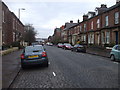
Hartington Place, Carlisle
The street is still paved with old-fashioned setts
Image: © John Lord
Taken: 25 Mar 2010
0.06 miles
6

War memorial, Our Lady and St Joseph's Church
Commemorating the men of this Roman Catholic parish who lost their lives in the Great War. 74 names are recorded - a full list, together with background details of the men, is available from the Carlisle branch of the British Legion http://branches.britishlegion.org.uk/branches/carlisle/ww1-heroes-walk-of-honour/memorial-36-our-lady-and-st-josephs-war-memorial .
View of the church from Warwick Road here Image .
Image: © Rose and Trev Clough
Taken: 23 Oct 2015
0.06 miles
7
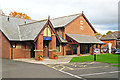
New Waterton Hall
The parish hall of Our Lady and St Joseph's Roman Catholic Church, Warwick Square, in whose grounds it stands. The building is also available for use by the community.
The 'old' Waterton Hall faced directly onto the street. It lasted about 100 years, before demolition in 2007. A block of flats was built in its place, with the new hall behind.
The hall is named after Canon Waterton, a former Rector who was instrumental in the building of the present church, which opened in 1893 (obituary http://archive.thetablet.co.uk/article/11th-february-1911/27/obituary ).
Image: © Rose and Trev Clough
Taken: 23 Oct 2015
0.06 miles
8
Benchmark on wall in front of #41 Chiswick Street
Ordnance Survey pivot benchmark described on the Bench Mark Database at http://www.bench-marks.org.uk/bm38332
Image: © Roger Templeman
Taken: 18 Jun 2011
0.06 miles
9
No. 41 Chiswick Street
There is an Ordnance Survey benchmark Image on top of the wall under railings right of the gate
Image: © Luke Shaw
Taken: 19 Aug 2019
0.06 miles
10
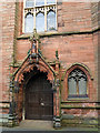
Door, Our Lady and St Joseph's Church
A photo of the whole building can be seen here Image . The door is in the tower, facing on to Warwick Square.
The church is a listed building, the description given by Historic England https://historicengland.org.uk/listing/the-list/list-entry/1197148 mentions 'double doors in pointed arch within a cusped and pedimented porch with Statue of Our Lady'.
Image: © Rose and Trev Clough
Taken: 23 Oct 2015
0.06 miles