IMAGES TAKEN NEAR TO
Aglionby Street, CARLISLE, CA1 1JP
Introduction
This page details the photographs taken nearby to Aglionby Street, CA1 1JP by members of the Geograph project.
The Geograph project started in 2005 with the aim of publishing, organising and preserving representative images for every square kilometre of Great Britain, Ireland and the Isle of Man.

There are currently over 7.5m images from over14,400 individuals and you can help contribute to the project by visiting https://www.geograph.org.uk
Image Map
Images are licensed for reuse under creativecommons.org/licenses/by-sa/2.0
Notes
- Clicking on the map will re-center to the selected point.
- The higher the marker number, the further away the image location is from the centre of the postcode.
Image Listing (440 Images Found)
Images are licensed for reuse under creativecommons.org/licenses/by-sa/2.0
Image
Details
Distance
1
Benchmark on wall of #2 Alfred Street South
Ordnance Survey cut mark benchmark described on the Bench Mark Database at http://www.bench-marks.org.uk/bm38329
Image: © Roger Templeman
Taken: 18 Jun 2011
0.03 miles
2
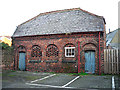
Old stables, Portland Square
Situated to the rear of 13-14 Portland Square (large terraced houses now used as NHS offices).
The stable was built some time between 1872 and 1901. In later years it was extended and used as a garage and workshop. The building was considered for listing in 2010, but did not meet the criteria - see PastScape for details http://www.pastscape.org.uk/hob.aspx?hob_id=1523077 .
There are garage-type doors at the back, accessed from a lane - see Image .
Image: © Rose and Trev Clough
Taken: 28 Dec 2017
0.05 miles
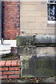
4
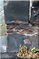
Eroded benchmark on wall in front of Baptist Church, Aglionby Street
Ordnance Survey cut mark benchmark described on the Bench Mark Database at http://www.bench-marks.org.uk/bm38334
Image: © Roger Templeman
Taken: 18 Jun 2011
0.06 miles
6
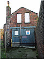
Old stables, Portland Square - rear access
For front view of building and information, see Image .
Image: © Rose and Trev Clough
Taken: 28 Dec 2017
0.06 miles
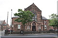
7
Baptist Church on Aglionby Street
There is an Ordnance Survey benchmark Image on the wall pier at the street corner
Image: © Luke Shaw
Taken: 19 Aug 2019
0.06 miles
8
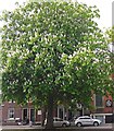
An urban horse chestnut tree in bloom
Located in Cecil Street, Carlisle.
Image: © Rose and Trev Clough
Taken: 12 May 2017
0.06 miles
9

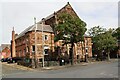
Railings, Portland Square Gardens
The gardens were laid out in 1870, as the surrounding square was being developed with houses. Originally reserved for the well-to-do residents, it later became a public park.
The wall and railings are Grade II listed. The Historic England description http://www.imagesofengland.org.uk/details/default.aspx?id=386838 mentions that the ironwork is impressed with the name of the foundry - Lees & Graham of Carlisle. That will be something to look for, one of these days.
Image: © Rose and Trev Clough
Taken: 12 May 2017
0.07 miles