IMAGES TAKEN NEAR TO
Dukes Road, CARLISLE, CA1 1JD
Introduction
This page details the photographs taken nearby to Dukes Road, CA1 1JD by members of the Geograph project.
The Geograph project started in 2005 with the aim of publishing, organising and preserving representative images for every square kilometre of Great Britain, Ireland and the Isle of Man.

There are currently over 7.5m images from over14,400 individuals and you can help contribute to the project by visiting https://www.geograph.org.uk
Image Map
Images are licensed for reuse under creativecommons.org/licenses/by-sa/2.0
Notes
- Clicking on the map will re-center to the selected point.
- The higher the marker number, the further away the image location is from the centre of the postcode.
Image Listing (284 Images Found)
Images are licensed for reuse under creativecommons.org/licenses/by-sa/2.0
Image
Details
Distance
1
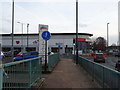
Benchmark on gatepost at Sands Centre carpark entrance
Ordnance Survey cut mark benchmark described on the Bench Mark Database at http://www.bench-marks.org.uk/bm31058
Image: © Roger Templeman
Taken: 30 Jul 2011
0.03 miles
2
Exit from Sands carpark onto Newmarket Road
There is an OS benchmark Image on the gatepost at the left hand side of the exit
Image: © Roger Templeman
Taken: 24 Jul 2015
0.03 miles
3
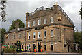
The Turf, Carlisle - August 2016
Built 1839-40 as a grandstand hotel for the racecourse, the building was extended in 1874 to a design by Daniel Birkett. It is Grade II listed.
A "State Managed" pub from September 1916 until sold for £26,265 to Eden Construction Limited in 1973.
Image: © The Carlisle Kid
Taken: 9 Aug 2016
0.04 miles
5

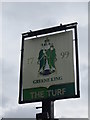
Time for a sit down and a pint
The Turf, Carlisle. Taken just off route.
Image: © Ian S
Taken: 2 Apr 2012
0.05 miles
7
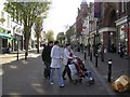
Scotch Street, Carlisle
Heading SSE towards the city centre
Image: © Kenneth Allen
Taken: 8 Oct 2009
0.06 miles
8
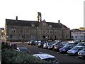
Magistrates Court, Carlisle
It is located at Rickergate
Image: © Kenneth Allen
Taken: 8 Oct 2009
0.06 miles
9
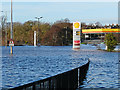
Hardwicke Circus under water
There is a roundabout down there, with a garden in the middle. Rising out of it is a statue on a column (see photo http://www.geograph.org.uk/photo/3611892 ).
Beyond the petrol station, the road emerges at Stanwix Bank.
(This photo taken with zoom lens from Georgian Way)
Image: © Rose and Trev Clough
Taken: 6 Dec 2015
0.06 miles
10
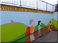
Access to Hardwicke Circus
Hardwicke Circus is the large roundabout at the southern end of the Eden Bridge. The centre of the roundabout is an attractive sunken public space, with subways decorated with mosaics leading under the road in all directions. This way in, from the Sands, extols the connections of Carlisle with Hadrian's Wall.
Image: © Oliver Dixon
Taken: 25 Jan 2016
0.06 miles