IMAGES TAKEN NEAR TO
Victoria Place, CARLISLE, CA1 1HP
Introduction
This page details the photographs taken nearby to Victoria Place, CA1 1HP by members of the Geograph project.
The Geograph project started in 2005 with the aim of publishing, organising and preserving representative images for every square kilometre of Great Britain, Ireland and the Isle of Man.

There are currently over 7.5m images from over14,400 individuals and you can help contribute to the project by visiting https://www.geograph.org.uk
Image Map
Images are licensed for reuse under creativecommons.org/licenses/by-sa/2.0
Notes
- Clicking on the map will re-center to the selected point.
- The higher the marker number, the further away the image location is from the centre of the postcode.
Image Listing (105 Images Found)
Images are licensed for reuse under creativecommons.org/licenses/by-sa/2.0
Image
Details
Distance
1
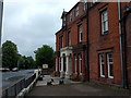
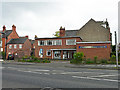
Abberley House, Victoria Place, Carlisle
Image: © Rob Purvis
Taken: 20 Jun 2018
0.02 miles
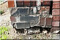
2
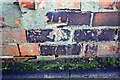
Benchmark on brick wall on south side of Victoria Place
Ordnance Survey cut mark benchmark described on the Bench Mark Database at www.bench-marks.org.uk/bm38809
Image: © Luke Shaw
Taken: 24 Aug 2019
0.03 miles
3
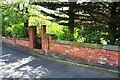
Wall on south side of Victoria Place east of Howard Place junction
There is an Ordnance Survey benchmark Image on the wall pier between the left hand brick gatepost and the left hand edge of the image
Image: © Roger Templeman
Taken: 24 Aug 2019
0.03 miles
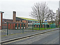
4
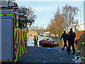
Flood rescue boats in Lismore Place
Newman RC secondary school is on the right, and there are houses on the other side of the road.
Image: © Rose and Trev Clough
Taken: 6 Dec 2015
0.04 miles
5
Christian Science Church
On Victoria Place.
Image: © Rose and Trev Clough
Taken: 27 Apr 2014
0.05 miles
6
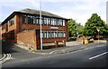
Armstrong Watson building on west side of Lismore Place and south side of Victoria Place
There is an Ordnance Survey benchmark Image on the pier at the near end of the brick wall abutting the left hand side of the building
Image: © Luke Shaw
Taken: 24 Aug 2019
0.05 miles
7
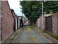
Narrow side road off Victoria Place, Carlisle
Image: © Rob Purvis
Taken: 20 Jun 2018
0.05 miles
8
Disused buildings, Newman Catholic School
View from Lismore Street.
For information see Image .
Image: © Rose and Trev Clough
Taken: 18 Feb 2018
0.06 miles
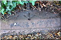
9
Damaged benchmark on corner wall pier at junction of Lismore Place and lane
Ordnance Survey cut mark benchmark described on the Bench Mark Database at www.bench-marks.org.uk/bm110604
Image: © Luke Shaw
Taken: 24 Aug 2019
0.06 miles
10
Benchmark on wall at NE corner of Chatsworth Square
Ordnance Survey pivot benchmark described on the Bench Mark Database at http://www.bench-marks.org.uk/bm69219
Image: © Roger Templeman
Taken: 24 Jul 2015
0.06 miles