IMAGES TAKEN NEAR TO
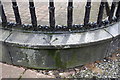
Spencer Street, CARLISLE, CA1 1BB
Introduction
This page details the photographs taken nearby to Spencer Street, CA1 1BB by members of the Geograph project.
The Geograph project started in 2005 with the aim of publishing, organising and preserving representative images for every square kilometre of Great Britain, Ireland and the Isle of Man.

There are currently over 7.5m images from over14,400 individuals and you can help contribute to the project by visiting https://www.geograph.org.uk
Image Map
Images are licensed for reuse under creativecommons.org/licenses/by-sa/2.0
Notes
- Clicking on the map will re-center to the selected point.
- The higher the marker number, the further away the image location is from the centre of the postcode.
Image Listing (656 Images Found)
Images are licensed for reuse under creativecommons.org/licenses/by-sa/2.0
Image
Details
Distance
1
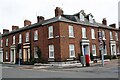
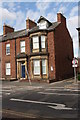
Houses at junction of Spencer Street and Chiswick Street
There is an Ordnance Survey benchmark Image on the wall with railings at the corner
Image: © Luke Shaw
Taken: 19 Aug 2019
0.01 miles
2
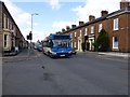
Bus, Spencer Street, Carlisle
Chiswick Street is to the right
Image: © Kenneth Allen
Taken: 19 Apr 2013
0.01 miles
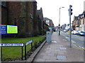
3
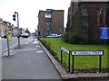
Spencer Street, Carlisle
Looking SSE from Lonsdale Street
Image: © Kenneth Allen
Taken: 19 Apr 2013
0.02 miles
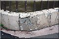
4
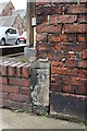
Benchmark on side of #49 Spencer Street
Ordnance Survey cut mark benchmark described on the Bench Mark Database at http://www.bench-marks.org.uk/bm38331
Image: © Roger Templeman
Taken: 18 Jun 2011
0.02 miles
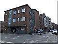
5
#49 Spencer Street, home of fmc training services
There is an OS benchmark Image on a stone at the near corner, right hand face, of the building
Image: © Roger Templeman
Taken: 5 Jul 2018
0.02 miles
6
The Carlisle Conservative Club
Pictured along Spencer Street
Image: © Kenneth Allen
Taken: 19 Apr 2013
0.03 miles
7
Benchmark on wall outside #1 Chiswick Street
Ordnance Survey cut mark benchmark described on the Bench Mark Database at http://www.bench-marks.org.uk/bm38333
Image: © Roger Templeman
Taken: 18 Jun 2011
0.03 miles
8
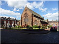
Elim Community Church
Known as St Paul's Elim Pentecostal Church until 2001. For more information visit the Elim website at http://www.elimcarlisle.org/default.asp
Image: © Jon Alexander
Taken: 21 Jun 2018
0.04 miles
9
Benchmark on wall at junction of roads
Ordnance Survey pivot benchmark described on the Bench Mark Database at http://www.bench-marks.org.uk/bm38330
Image: © Roger Templeman
Taken: 18 Jun 2011
0.04 miles
10
Lonsdale Street, Carlisle
Heading west from the junction with Spencer Street
Image: © Kenneth Allen
Taken: 19 Apr 2013
0.04 miles