IMAGES TAKEN NEAR TO
Hutton End, PENRITH, CA11 9TT
Introduction
This page details the photographs taken nearby to CA11 9TT by members of the Geograph project.
The Geograph project started in 2005 with the aim of publishing, organising and preserving representative images for every square kilometre of Great Britain, Ireland and the Isle of Man.

There are currently over 7.5m images from over14,400 individuals and you can help contribute to the project by visiting https://www.geograph.org.uk
Image Map
Images are licensed for reuse under creativecommons.org/licenses/by-sa/2.0
Notes
- Clicking on the map will re-center to the selected point.
- The higher the marker number, the further away the image location is from the centre of the postcode.
Image Listing (24 Images Found)
Images are licensed for reuse under creativecommons.org/licenses/by-sa/2.0
Image
Details
Distance
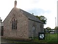
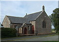
1
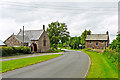
Hutton End
A small settlement on a minor road between Penrith and Carlisle.
The village hall, on the left, was originally a chapel and Sunday school.
Image: © Rose and Trev Clough
Taken: 15 Jun 2014
0.04 miles
2
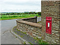
A Victorian postbox at Hutton End
Set in the wall of a house which can be seen on the left in this photo Image .
Image: © Rose and Trev Clough
Taken: 15 Jun 2014
0.04 miles
3
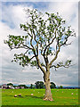
Ash tree in a field, with sheep
The tree has several dead branches, this can happen for various reasons and it would require a close examination to find out what it was.
Image: © Rose and Trev Clough
Taken: 15 Jun 2014
0.04 miles
5
Hutton End Village Hall
Clearly a former chapel.
Image: © David Purchase
Taken: 17 Oct 2016
0.04 miles
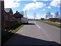
6
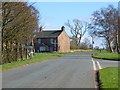
Hutton End, Skelton
Looking along the road to Penrith.
Image: © Andrew Smith
Taken: 8 Apr 2014
0.04 miles
7
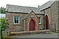
Door to Hutton End Village Hall
The hall, originally a chapel and Sunday school, was purchased by the local community in 1949 (information from Parish Council http://www.skeltonparish.co.uk/files/spapjune2011.pdf ).
Image: © Rose and Trev Clough
Taken: 15 Jun 2014
0.04 miles
8
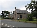
Hutton End
I was puzzled to where the chapel had gone on the maps, but it is now the village hall.
Image: © Richard Webb
Taken: 2 Jul 2014
0.04 miles
9
Village Hall, Hutton End
Previously a chapel and Sunday school.
Image: © JThomas
Taken: 10 Oct 2015
0.04 miles
10
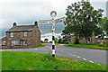
Road junction with renovated signpost, Hutton End
The more modern road sign on the right of the picture indicates Penrith 7 and Carlisle 12 miles.
Image: © Rose and Trev Clough
Taken: 15 Jun 2014
0.05 miles