IMAGES TAKEN NEAR TO
Skelton, PENRITH, CA11 9SX
Introduction
This page details the photographs taken nearby to CA11 9SX by members of the Geograph project.
The Geograph project started in 2005 with the aim of publishing, organising and preserving representative images for every square kilometre of Great Britain, Ireland and the Isle of Man.

There are currently over 7.5m images from over14,400 individuals and you can help contribute to the project by visiting https://www.geograph.org.uk
Image Map
Images are licensed for reuse under creativecommons.org/licenses/by-sa/2.0
Notes
- Clicking on the map will re-center to the selected point.
- The higher the marker number, the further away the image location is from the centre of the postcode.
Image Listing (5 Images Found)
Images are licensed for reuse under creativecommons.org/licenses/by-sa/2.0
Image
Details
Distance
1
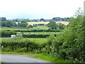
Pastoral landscape near Skelton
Skelton village Image can be seen in the distance.
Image: © Oliver Dixon
Taken: 21 Jul 2016
0.12 miles
2
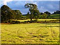
Farmland, Skelton
Cut silage fields to the north of the village.
Image: © Andrew Smith
Taken: 23 Aug 2014
0.19 miles
3
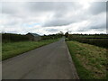
Road heading towards Skelton
Looking south-eastward.
Image: © Peter Wood
Taken: 10 Oct 2020
0.23 miles
4
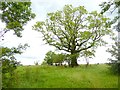
Tree near Skelton
A fine specimen of an ash tree by the road from Unthank to Skelton.
Image: © Oliver Dixon
Taken: 21 Jul 2016
0.25 miles
5
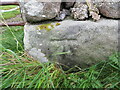
Ordnance Survey Cut Mark
The mark can be found on the wall of a roadside barn near to Skelton.
This benchmark has a recorded height of 205.203 metres above sea level.
For more detail see : https://www.bench-marks.org.uk/bm138706
Image: © Peter Wood
Taken: 10 Oct 2020
0.25 miles