IMAGES TAKEN NEAR TO
Lamonby, PENRITH, CA11 9SS
Introduction
This page details the photographs taken nearby to CA11 9SS by members of the Geograph project.
The Geograph project started in 2005 with the aim of publishing, organising and preserving representative images for every square kilometre of Great Britain, Ireland and the Isle of Man.

There are currently over 7.5m images from over14,400 individuals and you can help contribute to the project by visiting https://www.geograph.org.uk
Image Map
Images are licensed for reuse under creativecommons.org/licenses/by-sa/2.0
Notes
- Clicking on the map will re-center to the selected point.
- The higher the marker number, the further away the image location is from the centre of the postcode.
Image Listing (6 Images Found)
Images are licensed for reuse under creativecommons.org/licenses/by-sa/2.0
Image
Details
Distance
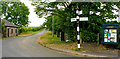
1

Lamonby Crossroads
Lamonby Signpost and Noticeboard with view of Village Road
Image: © R Pitt
Taken: 18 Jul 2018
0.07 miles
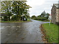
2
Lamonby Crossroads
Lamonby Signpost and Noticeboard with road to Hutton Roof
Image: © R Pitt
Taken: 18 Jul 2018
0.08 miles
3

Lamonby Crossroads
View towards Ellonby Road showing Blue Mill Barn a former Blacksmiths workshop and house.
Image: © R Pitt
Taken: 18 Jul 2018
0.09 miles
4
Crossroads in Lamonby
Looking north-westward.
Image: © Peter Wood
Taken: 10 Oct 2020
0.10 miles
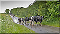
6

Fields east of Lamonby
The masts of the Skelton Transmitting Station Image are in the background.
Image: © David Purchase
Taken: 5 May 2012
0.19 miles