IMAGES TAKEN NEAR TO
Ellonby, PENRITH, CA11 9SN
Introduction
This page details the photographs taken nearby to CA11 9SN by members of the Geograph project.
The Geograph project started in 2005 with the aim of publishing, organising and preserving representative images for every square kilometre of Great Britain, Ireland and the Isle of Man.

There are currently over 7.5m images from over14,400 individuals and you can help contribute to the project by visiting https://www.geograph.org.uk
Image Map
Images are licensed for reuse under creativecommons.org/licenses/by-sa/2.0
Notes
- Clicking on the map will re-center to the selected point.
- The higher the marker number, the further away the image location is from the centre of the postcode.
Image Listing (3 Images Found)
Images are licensed for reuse under creativecommons.org/licenses/by-sa/2.0
Image
Details
Distance
1
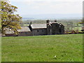
Hardrigg Hall & Peel
Grade 2 Listed farmhouse and ruined fortified tower with adjoining barn and stables. C14 tower for the Southaik family with C19 farmhouse, barns & stables.
Tower has extremely thick walls of large blocks of pink and grey sandstone; without roof. Exposed interior of tower has the remains of vaulted basement. Angle newel staircase has shouldered-arched doorway in basement, external round-arched doorway (now blocked by gable wall of farmhouse) and 2 further round-arched doorways above. Medieval fireplaces on 2 levels and remains of 3 splayed windows in each wall.
Image: © Matthew Hatton
Taken: 23 May 2015
0.03 miles
2
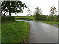
Crossroads at Hardrigg Hill
Looking south-westwards in the direction of Pringle House.
Image: © Peter Wood
Taken: 10 Oct 2020
0.22 miles
3
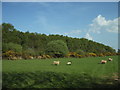
Roadends Wood
The southwest side of Roadends Wood which, in the 1930s, was 3 times the size it is now.
Image: © Alexander P Kapp
Taken: 11 May 2006
0.24 miles