IMAGES TAKEN NEAR TO
Ellonby, PENRITH, CA11 9SJ
Introduction
This page details the photographs taken nearby to CA11 9SJ by members of the Geograph project.
The Geograph project started in 2005 with the aim of publishing, organising and preserving representative images for every square kilometre of Great Britain, Ireland and the Isle of Man.

There are currently over 7.5m images from over14,400 individuals and you can help contribute to the project by visiting https://www.geograph.org.uk
Image Map
Images are licensed for reuse under creativecommons.org/licenses/by-sa/2.0
Notes
- Clicking on the map will re-center to the selected point.
- The higher the marker number, the further away the image location is from the centre of the postcode.
Image Listing (8 Images Found)
Images are licensed for reuse under creativecommons.org/licenses/by-sa/2.0
Image
Details
Distance
1
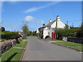
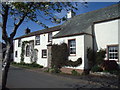
Cut Lawns & K6 in Ellonby
However deserted this village may look, 5 minute's later a huge tanker was driving down the street.
Image: © Matthew Hatton
Taken: 23 May 2015
0.02 miles
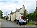
3
Junction of minor roads at Ellonby
Looking northward.
Image: © Peter Wood
Taken: 10 Oct 2020
0.06 miles
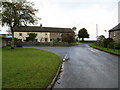
5
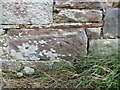
Ordnance Survey Cut Mark
The mark can be found on the roadside wall of a building at Limes farm, Ellonby.
This benchmark has a recorded height of 254.938 metres above sea level.
For more detail see : https://www.bench-marks.org.uk/bm138695
Image: © Peter Wood
Taken: 10 Oct 2020
0.06 miles
7
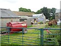
Farmyard at Ellonby Hall
A rich variety of agricultural bric-a-brac.
Image: © Oliver Dixon
Taken: 21 Jul 2016
0.09 miles
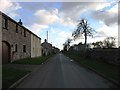
8
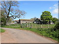
Barns attached to Ellonby Hall
Some of the building surrounding the farmhouse at Ellonby Hall are in the process of being re-roofed.
Image: © Matthew Hatton
Taken: 23 May 2015
0.11 miles