IMAGES TAKEN NEAR TO
Calthwaite, PENRITH, CA11 9RR
Introduction
This page details the photographs taken nearby to CA11 9RR by members of the Geograph project.
The Geograph project started in 2005 with the aim of publishing, organising and preserving representative images for every square kilometre of Great Britain, Ireland and the Isle of Man.

There are currently over 7.5m images from over14,400 individuals and you can help contribute to the project by visiting https://www.geograph.org.uk
Image Map
Images are licensed for reuse under creativecommons.org/licenses/by-sa/2.0
Notes
- Clicking on the map will re-center to the selected point.
- The higher the marker number, the further away the image location is from the centre of the postcode.
Image Listing (14 Images Found)
Images are licensed for reuse under creativecommons.org/licenses/by-sa/2.0
Image
Details
Distance
1
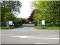
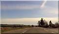
Animal and Plant Health Agency
Government agency located on the A6 near Plumptonfoot.
Image: © Oliver Dixon
Taken: 17 May 2018
0.04 miles
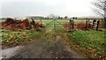
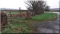
2
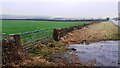
Field gateway on east side of A6 opposite Aitbank Common
There is an Ordnance Survey benchmark Image on the inside face of the gatepost at the far end of the gateway
Image: © Roger Templeman
Taken: 22 Dec 2021
0.08 miles
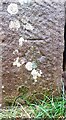
4
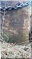
Benchmarked gatepost at field gateway on east side A6
Ordnance Survey cut mark benchmark levelled at 137.779m above Newlyn Datum verified 1969
Image: © Roger Templeman
Taken: 22 Dec 2021
0.11 miles
6
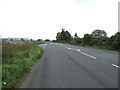
Field gateway from north side of road to Plumptonfoot near A6 junction
Image: © Luke Shaw
Taken: 22 Dec 2021
0.12 miles
7
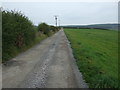
Track to Pears Gyhll Farm
Or Pears Gill Farm.
Also a footpath - heading east from the A6.
Image: © JThomas
Taken: 10 Oct 2015
0.16 miles
8
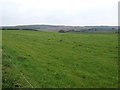
Grazing near Pears Gyhll Farm
Or Pears Gill Farm.
Image: © JThomas
Taken: 10 Oct 2015
0.18 miles
9
Benchmark on stone gatepost at gateway on north side of road to Plumptonfoot
Ordnance Survey cut mark benchmark levelled at 136.589m above Newlyn Datum verified in 1969
Image: © Roger Templeman
Taken: 22 Dec 2021
0.18 miles
10
Field gateway on north side on Plumptonfoot road at its junction with A6
There is an Ordnance Survey benchmark Image on the inside face of the gatepost at the far side of the gateway
Image: © Roger Templeman
Taken: 22 Dec 2021
0.18 miles