IMAGES TAKEN NEAR TO
Brackenburgh, Calthwaite, PENRITH, CA11 9PW
Introduction
This page details the photographs taken nearby to CA11 9PW by members of the Geograph project.
The Geograph project started in 2005 with the aim of publishing, organising and preserving representative images for every square kilometre of Great Britain, Ireland and the Isle of Man.

There are currently over 7.5m images from over14,400 individuals and you can help contribute to the project by visiting https://www.geograph.org.uk
Image Map
Images are licensed for reuse under creativecommons.org/licenses/by-sa/2.0
Notes
- Clicking on the map will re-center to the selected point.
- The higher the marker number, the further away the image location is from the centre of the postcode.
Image Listing (9 Images Found)
Images are licensed for reuse under creativecommons.org/licenses/by-sa/2.0
Image
Details
Distance
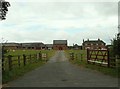
1
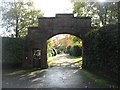
The entrance to Brackenburgh
Nice to have your own postbox at your front gate!
Image: © David Purchase
Taken: 18 Oct 2019
0.03 miles
2
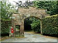
Imposing gateway with postbox, Brackenburgh Estate
Image: © Rose and Trev Clough
Taken: 14 Sep 2007
0.08 miles
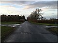
5
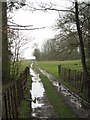
Farm track, Brackenburgh
View through the mud to part of Bank Wood.
Image: © Richard Webb
Taken: 30 Mar 2008
0.13 miles
6
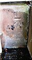
Benchmark on Brackenburgh Tower
Ordnance Survey cut mark benchmark levelled at 160.185m above Newlyn Datum verified 1970
Image: © Roger Templeman
Taken: 12 Jan 2022
0.14 miles
7
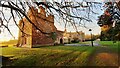
The Old Tower, Brackenburgh
There is an Ordnance Survey benchmark Image on the right hand face of the tower 7.6m from its near corner
Image: © Roger Templeman
Taken: 12 Jan 2022
0.14 miles
8
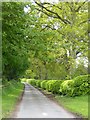
A neatly trimmed beech hedge
At Brackenburgh.
Image: © Oliver Dixon
Taken: 17 May 2018
0.22 miles