IMAGES TAKEN NEAR TO
Calthwaite, PENRITH, CA11 9PR
Introduction
This page details the photographs taken nearby to CA11 9PR by members of the Geograph project.
The Geograph project started in 2005 with the aim of publishing, organising and preserving representative images for every square kilometre of Great Britain, Ireland and the Isle of Man.

There are currently over 7.5m images from over14,400 individuals and you can help contribute to the project by visiting https://www.geograph.org.uk
Image Map
Images are licensed for reuse under creativecommons.org/licenses/by-sa/2.0
Notes
- Clicking on the map will re-center to the selected point.
- The higher the marker number, the further away the image location is from the centre of the postcode.
Image Listing (3 Images Found)
Images are licensed for reuse under creativecommons.org/licenses/by-sa/2.0
Image
Details
Distance
1
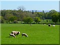
Pasture, Hesket
With the Pennines in the background.
Image: © Andrew Smith
Taken: 28 Apr 2011
0.04 miles
2
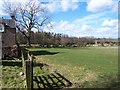
Field and Wood.
No sign of the water marked on the map perhaps hidden in the wood?
Image: © John Holmes
Taken: 29 Mar 2006
0.09 miles
3
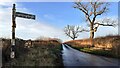
Road towards Field Head at Knowbrow T-junction
There is a Cumberland County Council finger signpost Image in the verge on the left hand side of the road
Image: © Roger Templeman
Taken: 12 Jan 2022
0.20 miles