IMAGES TAKEN NEAR TO
Petteril Terrace, PENRITH, CA11 9NU
Introduction
This page details the photographs taken nearby to Petteril Terrace, CA11 9NU by members of the Geograph project.
The Geograph project started in 2005 with the aim of publishing, organising and preserving representative images for every square kilometre of Great Britain, Ireland and the Isle of Man.

There are currently over 7.5m images from over14,400 individuals and you can help contribute to the project by visiting https://www.geograph.org.uk
Image Map
Images are licensed for reuse under creativecommons.org/licenses/by-sa/2.0
Notes
- Clicking on the map will re-center to the selected point.
- The higher the marker number, the further away the image location is from the centre of the postcode.
Image Listing (32 Images Found)
Images are licensed for reuse under creativecommons.org/licenses/by-sa/2.0
Image
Details
Distance
1
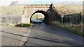
Bridge taking West Coast Main Line over road to Plumpton
There is an Ordnance Survey benchmark Image at the middle of the left hand wing wall of the bridge
Image: © Roger Templeman
Taken: 12 Jan 2022
0.03 miles
2
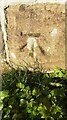
Benchmark on NW wing wall of Bridge CGJ7/189 Plumpton Road
Ordnance Survey cut mark benchmark levelled at 123.660m above Newlyn Datum verified 1969
Image: © Roger Templeman
Taken: 12 Jan 2022
0.05 miles
3

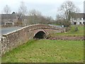
Middle Bridge over River Peterril, Brockleymoor
There is an Ordnance Survey benchmark Image on top of the left hand parapet at its near end
Image: © Roger Templeman
Taken: 12 Jan 2022
0.05 miles
4
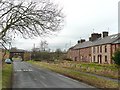
The road to the former Plumpton Station, Hesket Civil Parish
The railway bridge is in the middle distance, together with a letter box.
Image: © Humphrey Bolton
Taken: 27 Jan 2009
0.06 miles
5
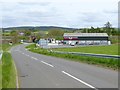
Aspatria Farmers
Agricultural suppliers on the site of the old Plumpton Station (closed 1948). The West Coast Main Line crosses the road immediately beyond.
Image: © Oliver Dixon
Taken: 17 May 2018
0.07 miles
6
Bridge over the River Petteril, Plumpton
This is at Brockleymoor and carries the road From Plumpton to Hutton-in-the Forest.
Image: © Humphrey Bolton
Taken: 27 Jan 2009
0.07 miles
7
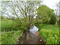
The infant River Petteril
Looking downstream at Plumpton.
Image: © Oliver Dixon
Taken: 17 May 2018
0.08 miles
8
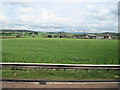
View across Meadowland towards Brocklemore
The Pot Place Garden Centre can be seen. From M6 southbound
Image: © John Firth
Taken: 13 May 2011
0.09 miles
9

Benchmark on east end of south parapet of Middle Bridge, Brockleymoor
Ordnance Survey rivet benchmark levelled at 124.409m above Newlyn Datum verified 1969
Image: © Roger Templeman
Taken: 12 Jan 2022
0.10 miles
10

River Petteril viewed over north parapet of Middle Bridge, Brockleymoor
Image: © Luke Shaw
Taken: 12 Jan 2022
0.10 miles