IMAGES TAKEN NEAR TO
Great Salkeld, PENRITH, CA11 9NE
Introduction
This page details the photographs taken nearby to CA11 9NE by members of the Geograph project.
The Geograph project started in 2005 with the aim of publishing, organising and preserving representative images for every square kilometre of Great Britain, Ireland and the Isle of Man.

There are currently over 7.5m images from over14,400 individuals and you can help contribute to the project by visiting https://www.geograph.org.uk
Image Map
Images are licensed for reuse under creativecommons.org/licenses/by-sa/2.0
Notes
- Clicking on the map will re-center to the selected point.
- The higher the marker number, the further away the image location is from the centre of the postcode.
Image Listing (7 Images Found)
Images are licensed for reuse under creativecommons.org/licenses/by-sa/2.0
Image
Details
Distance
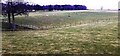
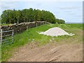
2
View through fieldgate on SW side of road near Keld Farm towards Greengill
Image: © Luke Shaw
Taken: 3 Feb 2022
0.02 miles
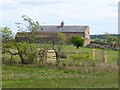
4
Field entrance near Green Ghyll Farm
Curlew Wood beyond.
Image: © Oliver Dixon
Taken: 17 May 2018
0.11 miles
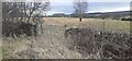
5
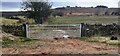
View towards Wan Fell through field gateway on SW side of rural road SE of Keld Farm
Image: © Roger Templeman
Taken: 3 Feb 2022
0.11 miles
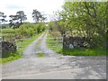
6
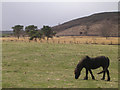
Grazing Horse near Greengill and Wan Fell
Image: © Chris Upson
Taken: 17 Apr 2006
0.22 miles