IMAGES TAKEN NEAR TO
North Dykes, Great Salkeld, PENRITH, CA11 9ND
Introduction
This page details the photographs taken nearby to CA11 9ND by members of the Geograph project.
The Geograph project started in 2005 with the aim of publishing, organising and preserving representative images for every square kilometre of Great Britain, Ireland and the Isle of Man.

There are currently over 7.5m images from over14,400 individuals and you can help contribute to the project by visiting https://www.geograph.org.uk
Image Map
Images are licensed for reuse under creativecommons.org/licenses/by-sa/2.0
Notes
- Clicking on the map will re-center to the selected point.
- The higher the marker number, the further away the image location is from the centre of the postcode.
Image Listing (9 Images Found)
Images are licensed for reuse under creativecommons.org/licenses/by-sa/2.0
Image
Details
Distance
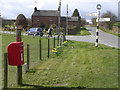
1
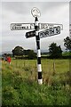
Signpost, letter box, noticeboard and fields at crossroads in North Dykes
The signpost has Milestone Society National ID: CU_NY5437
Image: © Roger Templeman
Taken: 28 Sep 2020
0.07 miles
2
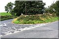
Junction of roads in North Dykes
Ordnance Survey records indicate that a benchmark levelled at 133.884m above Newlyn Datum was verified in 1972 on a stone at the base of the wall at the corner
Image: © Luke Shaw
Taken: 28 Sep 2020
0.08 miles
3
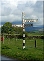
Old Direction Sign - Signpost by Salkeld Dykes, Great Salkeld parish
Annulus finial - 4 arms; Cumberland named halo by the UC road, in parish of Great Salkeld (Eden District), Salkeld Dykes.
Surveyed
Milestone Society National ID: CU_NY5437
Image: © Alan Rosevear
Taken: 11 May 2012
0.10 miles
6
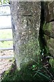
Benchmark on gatepost at gateway on south side of Garland Lane
Ordnance Survey cut mark benchmark levelled at 133.474m above Newlyn Datum verified 1972
Image: © Roger Templeman
Taken: 28 Sep 2020
0.16 miles
7
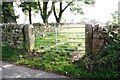
Field gateway on south side of Garland Lane at Croft House Farm
There is an Ordnance Survey benchmark Image on the road face of the near gatepost of the gateway
Image: © Roger Templeman
Taken: 28 Sep 2020
0.18 miles
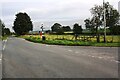
8
Track, Great Salkeld
Amid a patchwork of small fields at North Dykes.
Image: © Andrew Smith
Taken: 30 Nov 2012
0.18 miles
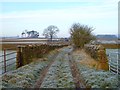
9
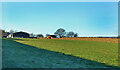
Wain Gate farmland
A wintry view of grazing land taken from the lane called Wain Gate, just to the north of Great Salkeld.
Image: © Mary and Angus Hogg
Taken: 18 Dec 2021
0.25 miles