IMAGES TAKEN NEAR TO
Inglewood Bank, PENRITH, CA11 9LH
Introduction
This page details the photographs taken nearby to Inglewood Bank, CA11 9LH by members of the Geograph project.
The Geograph project started in 2005 with the aim of publishing, organising and preserving representative images for every square kilometre of Great Britain, Ireland and the Isle of Man.

There are currently over 7.5m images from over14,400 individuals and you can help contribute to the project by visiting https://www.geograph.org.uk
Image Map
Images are licensed for reuse under creativecommons.org/licenses/by-sa/2.0
Notes
- Clicking on the map will re-center to the selected point.
- The higher the marker number, the further away the image location is from the centre of the postcode.
Image Listing (6 Images Found)
Images are licensed for reuse under creativecommons.org/licenses/by-sa/2.0
Image
Details
Distance
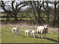
1
Burrell Green
The farm lies within the parish of Great Salkeld and is seen from the Banty Beck bridleway.
Image: © Greg Fitchett
Taken: 2 Feb 2013
0.02 miles
2
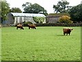
Burrell Green Farm
Burrell Green Farm specialises in rare breeds, particularly Highland cattle.
Image: © Oliver Dixon
Taken: 7 Oct 2020
0.02 miles
3
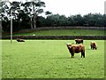
Highland cattle at Burrell Green Farm
Burrell Green Farm specialises in rare breeds, particularly Highland cattle.
Image: © Oliver Dixon
Taken: 7 Oct 2020
0.11 miles
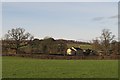
4
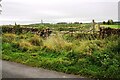
Field gateway on west side of road into forestry at Ladyrigg Farm
Ordnance Survey documents indicate that a benchmark levelled at 131.395m above Newlyn Datum was verified in 1972 on a gatepost at the left hand side of this gateway
Image: © Roger Templeman
Taken: 28 Sep 2020
0.18 miles
5
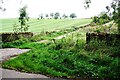
Track to Wolfa from rural road SW of Salkeld Dykes
Ordnance Survey documents indicate that a benchmark levelled at 119.353m above Newlyn Datum was verified in 1972 on a gatepost at this junction
Image: © Roger Templeman
Taken: 28 Sep 2020
0.20 miles