IMAGES TAKEN NEAR TO
Anchor Close, PENRITH, CA11 9HQ
Introduction
This page details the photographs taken nearby to Anchor Close, CA11 9HQ by members of the Geograph project.
The Geograph project started in 2005 with the aim of publishing, organising and preserving representative images for every square kilometre of Great Britain, Ireland and the Isle of Man.

There are currently over 7.5m images from over14,400 individuals and you can help contribute to the project by visiting https://www.geograph.org.uk
Image Map
Images are licensed for reuse under creativecommons.org/licenses/by-sa/2.0
Notes
- Clicking on the map will re-center to the selected point.
- The higher the marker number, the further away the image location is from the centre of the postcode.
Image Listing (74 Images Found)
Images are licensed for reuse under creativecommons.org/licenses/by-sa/2.0
Image
Details
Distance
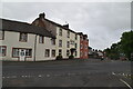
2
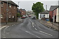
Scotland Road, Penrith
The building to the left of the camera position is the former Grey Bull Inn and there is an Ordnance Survey flush bracket benchmark on the bottom quoin at the wall corner (photograph Image).
Image: © Adrian Taylor
Taken: 10 Sep 2020
0.09 miles
4
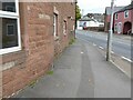
Benchmark, Scotland Road
Mounted on the corner of the former Grey Bull Inn, now a private house, this Ordnance Survey flush bracket benchmark number 1412 marks a height of 148.9143m above sea level (Ordnance Datum Newlyn) last levelled in 1953 and verified in 1972 (location photograph Image).
Image: © Adrian Taylor
Taken: 10 Sep 2020
0.10 miles
6
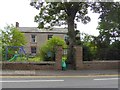
Cockell House, Drover's Lane, Penrith
The green plaque on the fence records "John Macadam General Surveyor of Roads lived here c 1820"
Image: © Oliver Dixon
Taken: 21 Jul 2016
0.10 miles
7
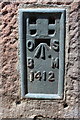
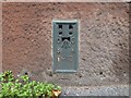
Benchmark on former Grey Bull Inn
Ordnance Survey flush bracket (serial number 1412) benchmark described on the Bench Mark Database at http://www.bench-marks.org.uk/bm2422
Image: © Roger Templeman
Taken: 26 May 2015
0.10 miles
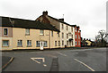
8
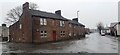
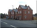
Former Grey Bull Inn at junction of Scotland Road and Robinson Street
There is an Ordnance Survey flush bracket benchmark Image on the right hand corner of the building
Image: © Luke Shaw
Taken: 16 Feb 2022
0.10 miles
9
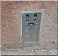
Ordnance Survey Flush Bracket (1412)
This OS Flush Bracket can be found on the former Grey Bull PH. It marks a point 148.914m above mean sea level.
Image: © Adrian Dust
Taken: 14 Sep 2022
0.10 miles
10
The Acorn Guest House
Beside Scotland Road, Penrith.
Image: © David Rogers
Taken: 22 Jan 2010
0.11 miles