IMAGES TAKEN NEAR TO
Edenhall, PENRITH, CA11 8TD
Introduction
This page details the photographs taken nearby to CA11 8TD by members of the Geograph project.
The Geograph project started in 2005 with the aim of publishing, organising and preserving representative images for every square kilometre of Great Britain, Ireland and the Isle of Man.

There are currently over 7.5m images from over14,400 individuals and you can help contribute to the project by visiting https://www.geograph.org.uk
Image Map
Images are licensed for reuse under creativecommons.org/licenses/by-sa/2.0
Notes
- Clicking on the map will re-center to the selected point.
- The higher the marker number, the further away the image location is from the centre of the postcode.
Image Listing (10 Images Found)
Images are licensed for reuse under creativecommons.org/licenses/by-sa/2.0
Image
Details
Distance
1
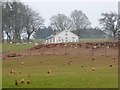
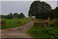
New farmhouse, Woodhead Farm
This farmhouse is obviously newly-built. Innumerable chickens have been let out to forage in the field below.
Image: © Oliver Dixon
Taken: 18 Mar 2015
0.02 miles
2
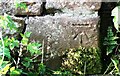
Benchmark on barn at Woodhead
Ordnance Survey cut mark benchmark levelled at 168.618m above Newlyn Datum in 1972
Image: © Luke Shaw
Taken: 18 Sep 2020
0.02 miles
3
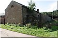
Farm buildings at Woodhead
There is an Ordnance Survey benchmark Image on the near corner, left hand face, of the barn
Image: © Luke Shaw
Taken: 18 Sep 2020
0.03 miles
4
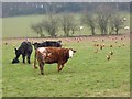
Cattle and chickens at Woodhead Farm
Innumerable chickens have been let out to forage in this field below Woodhead Farm.
Image: © Oliver Dixon
Taken: 18 Mar 2015
0.12 miles
6
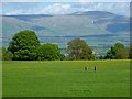
Pasture, Edenhall, Langwathby
A view of Cross Fell from the bridleway to the west of Wood Head.
Image: © Andrew Smith
Taken: 22 May 2013
0.15 miles
7
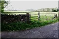
Field gateway on SW side of track to Edenhall Grange
There is an Ordnance Survey benchmark Image on the stone gatepost
Image: © Roger Templeman
Taken: 14 Sep 2020
0.16 miles
8
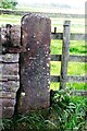
Benchmark on gatepost on SW side of SE end of track to Edenhall Grange
Ordnance Survey cut mark benchmark levelled at 157.554m above Newlyn Datum in 1962
Image: © Roger Templeman
Taken: 14 Sep 2020
0.16 miles
9
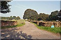
Track to Edenhall Grange
Since Charles Rispin photographed this track in 2006 ( Image] ), fences and house signs have been replaced, but the scene remains largely the same.
Image: © Richard Dorrell
Taken: 11 Sep 2014
0.18 miles
10
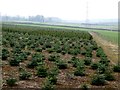
Christmas tree plantation near Woodhead Farm
Image: © Oliver Dixon
Taken: 18 Mar 2015
0.20 miles