IMAGES TAKEN NEAR TO
High Cote Ghyll, PENRITH, CA11 8TB
Introduction
This page details the photographs taken nearby to High Cote Ghyll, CA11 8TB by members of the Geograph project.
The Geograph project started in 2005 with the aim of publishing, organising and preserving representative images for every square kilometre of Great Britain, Ireland and the Isle of Man.

There are currently over 7.5m images from over14,400 individuals and you can help contribute to the project by visiting https://www.geograph.org.uk
Image Map
Images are licensed for reuse under creativecommons.org/licenses/by-sa/2.0
Notes
- Clicking on the map will re-center to the selected point.
- The higher the marker number, the further away the image location is from the centre of the postcode.
Image Listing (11 Images Found)
Images are licensed for reuse under creativecommons.org/licenses/by-sa/2.0
Image
Details
Distance
1
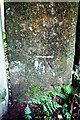
Benchmark on gatepost at entrance to Slatequarry Wood from bend in rural road
Ordnance Survey cut mark benchmark levelled at 127.251m above Newlyn Datum in 1972
Image: © Roger Templeman
Taken: 14 Sep 2020
0.05 miles
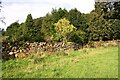
2
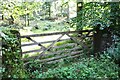
Entrance gateway to Slatequarry Wood from rural road near High Coatsgill
There is an Ordnance Survey benchmark Image on the gatepost at the right hand side of the gateway
Image: © Roger Templeman
Taken: 14 Sep 2020
0.08 miles
3
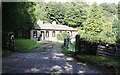
Cote Ghyll Cottage
Coatsgill Wood behind the house
Image: © Luke Shaw
Taken: 18 Sep 2020
0.09 miles
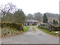
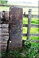
5
Eastern boundary wall of Cote Ghyll Cottage
There is an Ordnance Survey benchmark Image on the large stone at the base of the wall near the left hand side of the image
Image: © Luke Shaw
Taken: 18 Sep 2020
0.11 miles
6
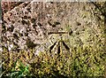
Benchmark on stone in boundary wall of Cote Ghyll Cottage
Ordnance Survey cut mark benchmark levelled at 109.800m above Newlyn Datum in 1972
Image: © Luke Shaw
Taken: 18 Sep 2020
0.12 miles
7
Benchmark on gatepost on SW side of SE end of track to Edenhall Grange
Ordnance Survey cut mark benchmark levelled at 157.554m above Newlyn Datum in 1962
Image: © Roger Templeman
Taken: 14 Sep 2020
0.23 miles
8
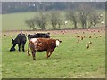
Cattle and chickens at Woodhead Farm
Innumerable chickens have been let out to forage in this field below Woodhead Farm.
Image: © Oliver Dixon
Taken: 18 Mar 2015
0.24 miles
10
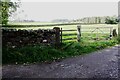
Field gateway on SW side of track to Edenhall Grange
There is an Ordnance Survey benchmark Image on the stone gatepost
Image: © Roger Templeman
Taken: 14 Sep 2020
0.24 miles