IMAGES TAKEN NEAR TO
Edenhall, PENRITH, CA11 8SZ
Introduction
This page details the photographs taken nearby to CA11 8SZ by members of the Geograph project.
The Geograph project started in 2005 with the aim of publishing, organising and preserving representative images for every square kilometre of Great Britain, Ireland and the Isle of Man.

There are currently over 7.5m images from over14,400 individuals and you can help contribute to the project by visiting https://www.geograph.org.uk
Image Map
Images are licensed for reuse under creativecommons.org/licenses/by-sa/2.0
Notes
- Clicking on the map will re-center to the selected point.
- The higher the marker number, the further away the image location is from the centre of the postcode.
Image Listing (11 Images Found)
Images are licensed for reuse under creativecommons.org/licenses/by-sa/2.0
Image
Details
Distance
2
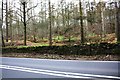
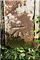
A686 passing Slatequarry Wood
In 1972 the Ordnance Survey levelled a cut mark benchmark at 111.500m above Newlyn Datum on one of the gateposts now embedded in the stone wall.
Image: © Luke Shaw
Taken: 19 Feb 2020
0.06 miles
4
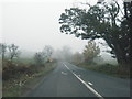
A686 nears Barbary Plains in gathering gloom
Image: © Colin Pyle
Taken: 3 Nov 2015
0.12 miles
5
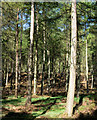
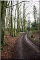
Slatequarry Wood
Based upon the open spacing of the trees Slatequarry Wood may well be an actual wood as opposed to a coniferous plantation; although at this low altitude some deciduous representation might then have been expected.
Image: © Trevor Littlewood
Taken: 9 May 2016
0.14 miles
6
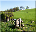
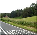
Field at Barbary Plains
Barbary Plains appears to be a location along the A686 near to Penrith.The field rises steeply above the eastern side of the road.
Image: © Trevor Littlewood
Taken: 9 May 2016
0.16 miles
7
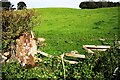
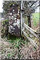
Former gateway to grass field from east side of A686 opposite Hazel Dub
There is an Ordnance Survey benchmark Image on the inside face of the stone gatepost
Image: © Luke Shaw
Taken: 14 Sep 2020
0.17 miles
8
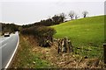
A686 heading north at Barbary Plains
There is an OS benchmark Image on the inside face of the far gatepost of the field gateway
Image: © Luke Shaw
Taken: 19 Feb 2020
0.19 miles
9
Benchmark on gatepost on east side A686 near Hazel Dub
Ordnance Survey cut mark benchmark described on the Bench Mark Database at www.bench-marks.org.uk/bm117019
Image: © Luke Shaw
Taken: 14 Sep 2020
0.20 miles
10
Benchmark on stone gatepost at gateway on east side of A686
Ordnance Survey cut mark benchmark levelled at 117.872m above Newlyn Datum in 1972
Image: © Luke Shaw
Taken: 19 Feb 2020
0.22 miles