IMAGES TAKEN NEAR TO
Victoria Road, PENRITH, CA11 8HR
Introduction
This page details the photographs taken nearby to Victoria Road, CA11 8HR by members of the Geograph project.
The Geograph project started in 2005 with the aim of publishing, organising and preserving representative images for every square kilometre of Great Britain, Ireland and the Isle of Man.

There are currently over 7.5m images from over14,400 individuals and you can help contribute to the project by visiting https://www.geograph.org.uk
Image Map
Images are licensed for reuse under creativecommons.org/licenses/by-sa/2.0
Notes
- Clicking on the map will re-center to the selected point.
- The higher the marker number, the further away the image location is from the centre of the postcode.
Image Listing (195 Images Found)
Images are licensed for reuse under creativecommons.org/licenses/by-sa/2.0
Image
Details
Distance
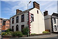
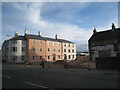
1
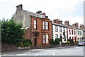
Houses on Victoria Road
There is an OS benchmark Image on the stone post at the end of the party wall between the nearest two houses, just right of a pole of a disc zone sign
Image: © Roger Templeman
Taken: 14 Jul 2015
0.01 miles
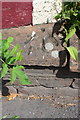
3
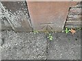
Ordnance Survey Cut Mark
This OS cut mark can be found on the dividing wall between Nos 2 & 3 Victoria Road. It marks a point 125.305m above mean sea level.
Image: © Adrian Dust
Taken: 14 Sep 2022
0.02 miles
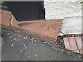
4
Benchmark at end of wall between nos. 2 and 3 Victoria Road
Ordnance Survey cut mark benchmark described on the Bench Mark Database at http://www.bench-marks.org.uk/bm68957
Image: © Roger Templeman
Taken: 14 Jul 2015
0.02 miles
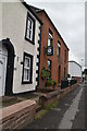
5
#36 Victoria Road at Roper Street junction
There is an OS benchmark Image on the low wall abutting the house at its near corner
Image: © Roger Templeman
Taken: 3 Jul 2015
0.02 miles
6
Benchmark on wall at #36 Victoria Road
Ordnance Survey pivot benchmark described on the Bench Mark Database at http://www.bench-marks.org.uk/bm28399
Image: © Roger Templeman
Taken: 3 Jul 2015
0.02 miles
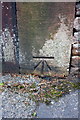
7
Ordnance Survey Pivot
This OS pivot can be found on No36 Victoria Road. It marks a point 125.726m above mean sea level.
Image: © Adrian Dust
Taken: 14 Sep 2022
0.02 miles
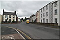
9
New housing at Roper Street / Victoria Road junction
Possible site of an old Ordnance Survey benchmark, see http://www.bench-marks.org.uk/bm68652
Image: © Roger Templeman
Taken: 14 Jul 2015
0.04 miles
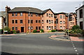
10
New development and roadway
These new houses are built in an acceptable local style. the new road will link Victoria Road with Southend Road.
Image: © Jonathan Thacker
Taken: 9 May 2011
0.04 miles