IMAGES TAKEN NEAR TO
Tulip Gardens, PENRITH, CA11 8EQ
Introduction
This page details the photographs taken nearby to Tulip Gardens, CA11 8EQ by members of the Geograph project.
The Geograph project started in 2005 with the aim of publishing, organising and preserving representative images for every square kilometre of Great Britain, Ireland and the Isle of Man.

There are currently over 7.5m images from over14,400 individuals and you can help contribute to the project by visiting https://www.geograph.org.uk
Image Map
Images are licensed for reuse under creativecommons.org/licenses/by-sa/2.0
Notes
- Clicking on the map will re-center to the selected point.
- The higher the marker number, the further away the image location is from the centre of the postcode.
Image Listing (6 Images Found)
Images are licensed for reuse under creativecommons.org/licenses/by-sa/2.0
Image
Details
Distance
1
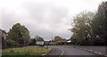
Public Footpath to Scaws and Beacon Edge
Fields on the edge of Penrith that have somehow still escaped the property developer.
Image: © Chris Upson
Taken: 16 Sep 2005
0.11 miles
2
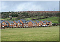
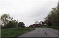
New housing in Penrith
Recently built brick housing on what was a greenfield site; currently, March 2020, OS mapping doesn't show the development.
The trees above are on Beacon Hill.
Image: © Trevor Littlewood
Taken: 9 Mar 2020
0.15 miles
3

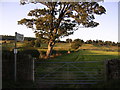
Pasture, Penrith
A view across the Eamont valley from a footpath above Carleton.
Image: © Andrew Smith
Taken: 22 May 2013
0.23 miles