IMAGES TAKEN NEAR TO
Hutton Roof, PENRITH, CA11 0XX
Introduction
This page details the photographs taken nearby to CA11 0XX by members of the Geograph project.
The Geograph project started in 2005 with the aim of publishing, organising and preserving representative images for every square kilometre of Great Britain, Ireland and the Isle of Man.

There are currently over 7.5m images from over14,400 individuals and you can help contribute to the project by visiting https://www.geograph.org.uk
Image Map
Images are licensed for reuse under creativecommons.org/licenses/by-sa/2.0
Notes
- Clicking on the map will re-center to the selected point.
- The higher the marker number, the further away the image location is from the centre of the postcode.
Image Listing (7 Images Found)
Images are licensed for reuse under creativecommons.org/licenses/by-sa/2.0
Image
Details
Distance
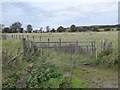
3
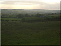
Field near Newsham
Looking towards Tarn Plantation. Blencathra Image dominates the skyline.
Image: © Oliver Dixon
Taken: 21 Oct 2016
0.05 miles
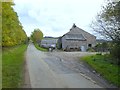
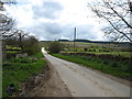
5
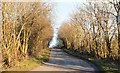
Minor road south-east of Newsham Farm
The road, lined with spindly trees, heading north-east.
Image: © Trevor Littlewood
Taken: 18 Nov 2018
0.13 miles
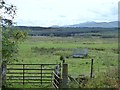
6
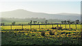
Roughly vegetated ground north-east from Newsham Bridge
A small area of rough pasture on the north side of a minor road, fenced off from a thoroughly cultivated field. The distant hills are Carrock Fell to the left and High Pike.
Image: © Trevor Littlewood
Taken: 18 Nov 2018
0.23 miles