IMAGES TAKEN NEAR TO
Greystoke, PENRITH, CA11 0TG
Introduction
This page details the photographs taken nearby to CA11 0TG by members of the Geograph project.
The Geograph project started in 2005 with the aim of publishing, organising and preserving representative images for every square kilometre of Great Britain, Ireland and the Isle of Man.

There are currently over 7.5m images from over14,400 individuals and you can help contribute to the project by visiting https://www.geograph.org.uk
Image Map
Images are licensed for reuse under creativecommons.org/licenses/by-sa/2.0
Notes
- Clicking on the map will re-center to the selected point.
- The higher the marker number, the further away the image location is from the centre of the postcode.
Image Listing (5 Images Found)
Images are licensed for reuse under creativecommons.org/licenses/by-sa/2.0
Image
Details
Distance
1
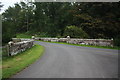
Bridge over North Petterill at Garth Wood Greystoke Estate
Image: © ben hollier
Taken: 25 Sep 2013
0.19 miles
2
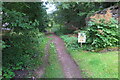
Track into the Greystoke Castle estate
Your Sat Nav is lying! The sign says. I half expected to find a pile of misdirected motorists further along the track.
Image: © Philip Jeffrey
Taken: 31 Jul 2022
0.19 miles
3
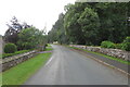
Woodland by Berrier road leaving Greystoke
Image: © Philip Jeffrey
Taken: 31 Jul 2022
0.22 miles
4
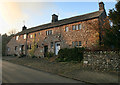
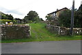
Greystoke
Cottages on Berrier Road in Greystoke.
Image: © Peter McDermott
Taken: 15 Nov 2011
0.24 miles
5
Electricity substation and its field
Image: © Philip Jeffrey
Taken: 31 Jul 2022
0.25 miles