IMAGES TAKEN NEAR TO
Greystoke, PENRITH, CA11 0TF
Introduction
This page details the photographs taken nearby to CA11 0TF by members of the Geograph project.
The Geograph project started in 2005 with the aim of publishing, organising and preserving representative images for every square kilometre of Great Britain, Ireland and the Isle of Man.

There are currently over 7.5m images from over14,400 individuals and you can help contribute to the project by visiting https://www.geograph.org.uk
Image Map
Images are licensed for reuse under creativecommons.org/licenses/by-sa/2.0
Notes
- Clicking on the map will re-center to the selected point.
- The higher the marker number, the further away the image location is from the centre of the postcode.
Image Listing (121 Images Found)
Images are licensed for reuse under creativecommons.org/licenses/by-sa/2.0
Image
Details
Distance
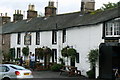
1
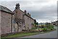
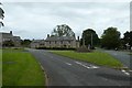
Houses in Greystoke
Substantial stone-built houses in the centre of the village.
Image: © Richard Dorrell
Taken: 25 Sep 2019
0.03 miles
2
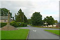
Greystoke Village crossroads
From the Village green looking East towards Penrith off the Berrier road.
Image: © Malcolm Carruthers
Taken: 7 Sep 2008
0.03 miles
3
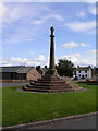
Market Cross - Greystoke
Site of a market licensed by Henry III to Thomas de Greystoke.
Image: © mauldy
Taken: 28 Jul 2007
0.04 miles
4
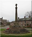
Old Central Cross on the village green, Greystoke
Greystoke Cross, old shaft, base and steps, by the UC road, in parish of Greystoke (Eden District), on Village Green, opposite Cross View.
Grade II listed.
List Entry Number: 1326705 https://historicengland.org.uk/listing/the-list/list-entry/1326705
Surveyed
Milestone Society National ID: CBED_GRE
Image: © Milestone Society
Taken: Unknown
0.04 miles
5
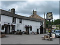
Boot and Shoe, Greystoke
Decent pint of Black Sheep
Image: © Alex McGregor
Taken: 13 Jul 2010
0.05 miles
6
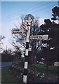
Old Direction Sign - Signpost by the B5288, Greystoke, Greystoke Parish
Pawn finial - 4 arms; Cumberland CC square end by the B5288 (was A594), in parish of Greystoke (Eden District), Greystoke village green.
Surveyed
Milestone Society National ID: CU_NY4430
Image: © Milestone Society
Taken: Unknown
0.05 miles
7
Market cross in Greystoke
Looking across part of the village from Berrier Road.
Image: © DS Pugh
Taken: 11 Jul 2020
0.05 miles
8
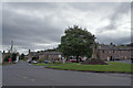
Centre of Greystoke village
Greystoke is a charming Cumbrian village with post office, pub, primary school and church.
The oak tree on the village green (pictured) was planted in 1977 by John Sealby, chairman at the time of Greystoke Parish Council, in commemoration of the silver jubilee of Queen Elizabeth II.
Image: © Richard Dorrell
Taken: 25 Sep 2019
0.05 miles
9
The Boot and Shoe, Greystoke
Many a jockey and at least one Grand National winning horse has downed a pint here.
Image: © Malcolm Carruthers
Taken: 7 Sep 2008
0.05 miles
10

Greystoke Village
As viewed from the Southern end of the B5288 heading into Greystoke with Berrier and Whitbarrow to the left, Johnby and Blencow straight on and Penrith to the right.
Image: © Malcolm Carruthers
Taken: 7 Sep 2008
0.06 miles