IMAGES TAKEN NEAR TO
Troutbeck, PENRITH, CA11 0SZ
Introduction
This page details the photographs taken nearby to CA11 0SZ by members of the Geograph project.
The Geograph project started in 2005 with the aim of publishing, organising and preserving representative images for every square kilometre of Great Britain, Ireland and the Isle of Man.

There are currently over 7.5m images from over14,400 individuals and you can help contribute to the project by visiting https://www.geograph.org.uk
Image Map
Images are licensed for reuse under creativecommons.org/licenses/by-sa/2.0
Notes
- Clicking on the map will re-center to the selected point.
- The higher the marker number, the further away the image location is from the centre of the postcode.
Image Listing (10 Images Found)
Images are licensed for reuse under creativecommons.org/licenses/by-sa/2.0
Image
Details
Distance
1
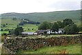
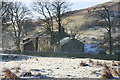
Blake Hills Farm
Situated in the Glenderamackin valley below Souther Fell.
Image: © Bill Boaden
Taken: 13 Aug 2011
0.02 miles
2
Blake Hills Farm
Nestles below Souther Fell.
Image: © Bob Jenkins
Taken: 29 Dec 2005
0.04 miles
3
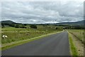
Passing Blake Hills Farm
Looking along the Mungrisdale to A66 road.
Image: © DS Pugh
Taken: 11 Jul 2020
0.10 miles
4
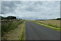
Road to Mungrisdale
Looking along the road leading from the A66.
Image: © DS Pugh
Taken: 11 Jul 2020
0.14 miles
5
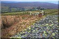
Lichen on Bridge Parapet
The farm just beyond the field is Blake Hills (Image), in the distance is Souther Fell (Image).
The green lichen is, I think, Rhizocarpon Geographicum and is quite common on hard acid rocks in upland areas. The names derives from its map-like appearance.
Image: © Mick Garratt
Taken: 19 Feb 2009
0.17 miles
6
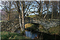
River Glenderamackin
Bridge crossing the River Glenderamackin near Blakebeck.
Image: © Peter McDermott
Taken: 15 Nov 2011
0.21 miles
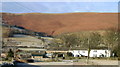
7
Wilton Hill Farm
behind is Souther Fell
Image: © Bob Jenkins
Taken: 29 Dec 2005
0.24 miles
8
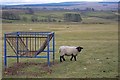
Field near Wilton Hill
A lonely Black Faced Suffolk (I think) in a field of Swaledales an Herdwicks.
Image: © Mick Garratt
Taken: 19 Feb 2009
0.24 miles
9
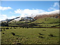
The upper Glenderamackin valley
Looking towards Knotts, at the southern end of Souther Fell.
Image: © David Purchase
Taken: 9 Feb 2018
0.25 miles
10
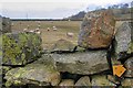
Top of Stile Over Wall
A precarious and rather pointless wall crossing. The path follows the far side of the wall for fifty or so metres before crossing it again through a gate. This side of the wall is clearly marked "No Path".
Image: © Mick Garratt
Taken: 19 Feb 2009
0.25 miles