IMAGES TAKEN NEAR TO
Penruddock, PENRITH, CA11 0RZ
Introduction
This page details the photographs taken nearby to CA11 0RZ by members of the Geograph project.
The Geograph project started in 2005 with the aim of publishing, organising and preserving representative images for every square kilometre of Great Britain, Ireland and the Isle of Man.

There are currently over 7.5m images from over14,400 individuals and you can help contribute to the project by visiting https://www.geograph.org.uk
Image Map
Images are licensed for reuse under creativecommons.org/licenses/by-sa/2.0
Notes
- Clicking on the map will re-center to the selected point.
- The higher the marker number, the further away the image location is from the centre of the postcode.
Image Listing (10 Images Found)
Images are licensed for reuse under creativecommons.org/licenses/by-sa/2.0
Image
Details
Distance
2
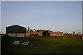
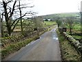
Access road for Spring Bank
Spring Bank, a detached house in farmland east of Great Mell Fell.
Image: © Trevor Littlewood
Taken: 30 Jun 2016
0.09 miles
3
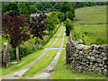
Road to Nabend
In between Great and Little Mell Fells
Image: © Michael Graham
Taken: 24 Jul 2011
0.12 miles
4
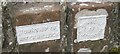
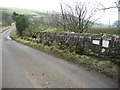
Old Boundary Markers on bridge northwest of Nab End
Parish Boundary Marker by the UC road, in parish of Hutton (Eden District), Nab End, centre of Southwest bridge parapet.
Inscriptions read:
TOWNSHIP OF
WATERMILLOCK
and
TOWNSHIP
OF
HUTTONSOIL
Surveyed
Milestone Society National ID: CU_HUSWML01pb
Image: © Milestone Society
Taken: Unknown
0.14 miles
5
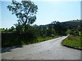
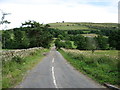
Bridge over Thackthwaite Beck
Looking south-east towards Nabend. The beck is a parish and township boundary.
Image: © Christine Johnstone
Taken: 10 Mar 2017
0.15 miles
6
Benchmark and boundary plates on Thackthwaite Beck bridge
The plates mark the boundary of the townships of Watermillock [left / east] and Huttonsgill [right / west]. The beck is now the boundary between the civil parishes of Matterdale and Hutton.
Image: © Christine Johnstone
Taken: 10 Mar 2017
0.15 miles
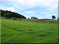
8
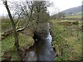
Thackthwaite Beck
Looking upstream [locally south-west] from the bridge on the Nabend road.
Image: © Christine Johnstone
Taken: 10 Mar 2017
0.16 miles
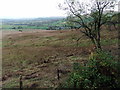
10
The lower east slopes of Great Mell Fell
Image: © David Purchase
Taken: 26 Jul 2013
0.25 miles