IMAGES TAKEN NEAR TO
Mellfell View, PENRITH, CA11 0QZ
Introduction
This page details the photographs taken nearby to Mellfell View, CA11 0QZ by members of the Geograph project.
The Geograph project started in 2005 with the aim of publishing, organising and preserving representative images for every square kilometre of Great Britain, Ireland and the Isle of Man.

There are currently over 7.5m images from over14,400 individuals and you can help contribute to the project by visiting https://www.geograph.org.uk
Image Map
Images are licensed for reuse under creativecommons.org/licenses/by-sa/2.0
Notes
- Clicking on the map will re-center to the selected point.
- The higher the marker number, the further away the image location is from the centre of the postcode.
Image Listing (11 Images Found)
Images are licensed for reuse under creativecommons.org/licenses/by-sa/2.0
Image
Details
Distance
1
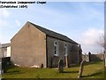
Penruddock Independent Chapel
This simple rectangular chapel was originally founded as a Dissenting Chapel. It subsequently became Presbyterian and is now URC.
In the early part of the eighteenth century it had links with Kendal Free Christian Chapel which is now Kendal Unitarian Chapel.
Image: © Don Kerr
Taken: 20 Mar 2003
0.04 miles
2
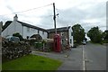
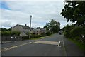
Herdwick Inn
Looking through the village of Penruddock.
Image: © DS Pugh
Taken: 11 Jul 2020
0.17 miles
3
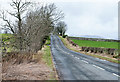
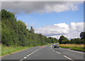
Minor road west of Penruddock
The road was once the route of the A66 before its realignment to pass south of the village.
Image: © Trevor Littlewood
Taken: 9 Mar 2020
0.17 miles
5

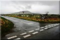
Westbound A66 near Hilltop Farm
A police car waits at the side of the A66 near Hill Top Farm.
Image: © David Dixon
Taken: 15 Feb 2013
0.19 miles
6
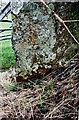
Benchmark on gatepost on north side of road north of Penruddock
Ordnance Survey cut mark benchmark described on the Bench Mark Database at www.bench-marks.org.uk/bm86959 . The mark is a survivor of the 1855/6 Penrith to Workington survey which was levelled at 911.567 feet above Liverpool Datum. The surveyor's description was 'Mark on East pier of gate opposite junction of road to Penruddock'
Image: © Roger Templeman
Taken: 19 Feb 2020
0.20 miles
7
Passing Penruddock Primary School
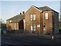
Looking through the village of Penruddock beside the Primary School.
Image: © DS Pugh
Taken: 11 Jul 2020
0.21 miles
8
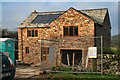
Penruddock
New house being built in Penruddock.
Image: © Peter McDermott
Taken: 15 Nov 2011
0.22 miles