IMAGES TAKEN NEAR TO
Low Rake, PENRITH, CA11 0QN
Introduction
This page details the photographs taken nearby to Low Rake, CA11 0QN by members of the Geograph project.
The Geograph project started in 2005 with the aim of publishing, organising and preserving representative images for every square kilometre of Great Britain, Ireland and the Isle of Man.

There are currently over 7.5m images from over14,400 individuals and you can help contribute to the project by visiting https://www.geograph.org.uk
Image Map
Images are licensed for reuse under creativecommons.org/licenses/by-sa/2.0
Notes
- Clicking on the map will re-center to the selected point.
- The higher the marker number, the further away the image location is from the centre of the postcode.
Image Listing (43 Images Found)
Images are licensed for reuse under creativecommons.org/licenses/by-sa/2.0
Image
Details
Distance
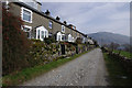
1
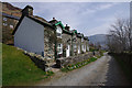
Rake Cottages, Glenridding
A terrace built for mine-workers by Greenside Road, which lead to Greenside Mine.
Image: © Ian Taylor
Taken: 30 Mar 2014
0.00 miles
2
Cottages on the Greenside Road, Glenridding
These terraces below The Rake were built for workers at the former Greenside Lead Mine a little further up the valley. A zoom shot from Keldas across the dale.
Image: © Karl and Ali
Taken: 22 May 2011
0.00 miles
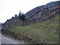
3
Terrace of Houses in Rake Cottages
Rake Cottages lie along Greenside Road and are part of the village of Glenridding. There are several short terraces; this one is seen from just above the road.
Image: © Trevor Littlewood
Taken: 20 Jan 2016
0.01 miles
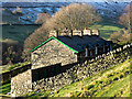
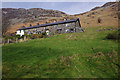
4
Miners Cottages, Greenside Road
These terraces housed miners from the Greenside Mine which produced lead and silver until its closure in 1961.
Image: © K A
Taken: 31 Jan 2010
0.02 miles
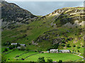
6
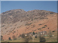
Rakes Cottages
The last houses on the way up Glenridding, on the south slope of Sheffield Pike.
Image: © Stephen Craven
Taken: 22 Mar 2003
0.03 miles
7
Rake Cottages, Glenridding
A terrace built for mine-workers, above Greenside Road and below the Rake (the slope up to the low point between Glenridding Dodd and Sheffield Pike).
Image: © Ian Taylor
Taken: 30 Mar 2014
0.04 miles
8
Above Glenridding
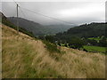
On the descent of Heron Pike
Image: © Michael Graham
Taken: 22 Jul 2012
0.04 miles
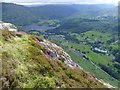
9
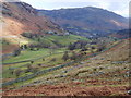
Glenridding
Looking down the valley towards Ullswater
Image: © Michael Graham
Taken: 1 Mar 2009
0.07 miles
10
Greenside Road, Glenridding
Terraced houses, built for mine-workers, by the road to Greenside Mine.
Image: © Ian Taylor
Taken: 30 Mar 2014
0.09 miles