IMAGES TAKEN NEAR TO
Glenridding, PENRITH, CA11 0PU
Introduction
This page details the photographs taken nearby to CA11 0PU by members of the Geograph project.
The Geograph project started in 2005 with the aim of publishing, organising and preserving representative images for every square kilometre of Great Britain, Ireland and the Isle of Man.

There are currently over 7.5m images from over14,400 individuals and you can help contribute to the project by visiting https://www.geograph.org.uk
Image Map
Images are licensed for reuse under creativecommons.org/licenses/by-sa/2.0
Notes
- Clicking on the map will re-center to the selected point.
- The higher the marker number, the further away the image location is from the centre of the postcode.
Image Listing (14 Images Found)
Images are licensed for reuse under creativecommons.org/licenses/by-sa/2.0
Image
Details
Distance
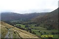
1
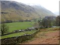
Braesteads Farm
Looking across Grisedale. The snowy slopes of St Sunday Crag beyond.
Image: © Oliver Dixon
Taken: 15 Mar 2015
0.01 miles
2
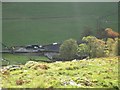
Braesteads Farm in the Grisdale Valley (Patterdale)
Braesteads Farm seen from above whilst walking along the path towards Birkhouse Moor and Red Tarn.
Image: © Graham Robson
Taken: 1 Nov 2011
0.03 miles
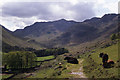
3

Braesteads and Grisedale
From the footpath running along its northern flank
Image: © Martin Dawes
Taken: 19 May 2012
0.05 miles
5
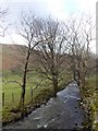
Tree-lined course of Grisedale Beck
Looking downstream.
Image: © Oliver Dixon
Taken: 15 Mar 2015
0.12 miles
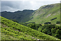
6
Grisedale from Helvellyn Footpath
Glaciated valley in Lake District with moraine ridges on valley floor
Image: © paul birrell
Taken: 20 Oct 2003
0.12 miles
7
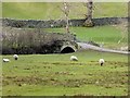
Farm bridge over Grisedale Beck
A private bridge (not part of the public right of way network) by Braesteads Farm.
Image: © Oliver Dixon
Taken: 15 Mar 2015
0.14 miles
8
Bracken slope in Grisedale
In early July the bracken cover is heading towards its maximum. The slope is on the valley's southern side. To the north where there's more bracken, the sunlit slope rises towards Striding Edge; the shadowed slopes rise towards Dollywaggon Pike and Nethermost Pike.
Image: © Trevor Littlewood
Taken: 1 Jul 2016
0.17 miles
9
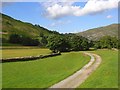
Grisedale
Green pastures just above Patterdale. The beck is to the left.
Image: © Andrew Smith
Taken: 20 Jun 2008
0.19 miles
10
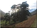
Scots Pines
I wonder who planted this stand of pines, when, and for what purpose? It seems to far away to be an effective wind break for the nearest farmstead at Braesteads
Image: © K A
Taken: 31 Jan 2010
0.19 miles