IMAGES TAKEN NEAR TO
Plumpton, PENRITH, CA11 0JD
Introduction
This page details the photographs taken nearby to CA11 0JD by members of the Geograph project.
The Geograph project started in 2005 with the aim of publishing, organising and preserving representative images for every square kilometre of Great Britain, Ireland and the Isle of Man.

There are currently over 7.5m images from over14,400 individuals and you can help contribute to the project by visiting https://www.geograph.org.uk
Image Map
Images are licensed for reuse under creativecommons.org/licenses/by-sa/2.0
Notes
- Clicking on the map will re-center to the selected point.
- The higher the marker number, the further away the image location is from the centre of the postcode.
Image Listing (29 Images Found)
Images are licensed for reuse under creativecommons.org/licenses/by-sa/2.0
Image
Details
Distance
1
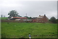
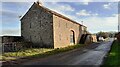
Lowstreet House Farm.
The M6 on the right must have made a huge change in this rural area.
Image: © John Holmes
Taken: 4 Apr 2006
0.03 miles
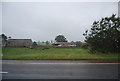
4
Blossom Barn on east side of rural road at Lowstreet
Image: © Roger Templeman
Taken: 12 Jan 2022
0.05 miles
5
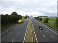
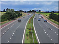
The M6 motorway, looking north
Seen from Plumpton Station Bridge. (Plumpton Station has of course long gone.)
Image: © David Purchase
Taken: 3 Oct 2017
0.06 miles
6
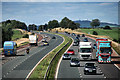
M6 Motorway
The M6 Motorway at Plumpton.
Image: © Peter McDermott
Taken: 4 Sep 2011
0.07 miles
7
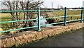
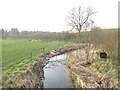
View along Old Petteril towards M6 from bridge north of Lowstreer
Image: © Luke Shaw
Taken: 12 Jan 2022
0.08 miles
8
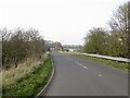
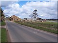
Towards Lowstreet
A minor road running parallel to the M6.
Image: © Richard Webb
Taken: 22 Mar 2022
0.09 miles
9
The M6, Plumpton
Looking north from the bridge west of Plumpton on the road to Unthank.
Image: © Andrew Smith
Taken: 19 Jul 2009
0.09 miles