IMAGES TAKEN NEAR TO
Stainton, PENRITH, CA11 0DU
Introduction
This page details the photographs taken nearby to CA11 0DU by members of the Geograph project.
The Geograph project started in 2005 with the aim of publishing, organising and preserving representative images for every square kilometre of Great Britain, Ireland and the Isle of Man.

There are currently over 7.5m images from over14,400 individuals and you can help contribute to the project by visiting https://www.geograph.org.uk
Image Map
Images are licensed for reuse under creativecommons.org/licenses/by-sa/2.0
Notes
- Clicking on the map will re-center to the selected point.
- The higher the marker number, the further away the image location is from the centre of the postcode.
Image Listing (16 Images Found)
Images are licensed for reuse under creativecommons.org/licenses/by-sa/2.0
Image
Details
Distance
1
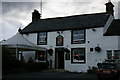
King's Arms, Stainton, Cumbria
Serves a good meal and a better pint!
Image: © Terry Johnson
Taken: 10 Jul 2006
0.03 miles
2
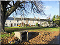
Houses across the green
Terraced houses in Stainton across the village Green.
Image: © Trevor Littlewood
Taken: 26 Nov 2021
0.09 miles
3
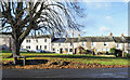
Houses across the green - 2
Terraced houses in Stainton seen across the village green.
Image: © Trevor Littlewood
Taken: 26 Nov 2021
0.10 miles
4
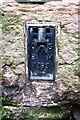
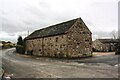
Benchmark on barn at Town End Farm
Ordnance Survey flush bracket (serial number 1393) benchmark described on the Bench Mark Database at www.bench-marks.org.uk/bm31
Image: © Roger Templeman
Taken: 19 Feb 2020
0.11 miles
5
Barn at Town End Farm
There is an Ordnance Survey flush bracket benchmark Image on the near corner of the barn on its right hand face
Image: © Roger Templeman
Taken: 19 Feb 2020
0.11 miles
6
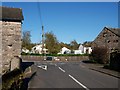
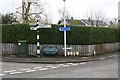
Junction St John's road Stainton
The junction with the Pavilion and St John's road Stainton.
Image: © Steve Houldsworth
Taken: 14 Oct 2011
0.11 miles
7
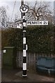
Old Direction Sign - Signpost in Stainton
Annulus finial - 4 arms; Cumberland CC named halo by the UC road, in parish of Dacre (Eden District), Stainton, junction St John's Rd and The Pavilion, road corner, in front of grit bin.
To be surveyed
Milestone Society National ID: CU_NY4828.
Image: © Milestone Society
Taken: Unknown
0.12 miles
8
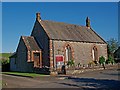
Stainton Methodist Church
The Methodist church St John's road Stainton.
Image: © Steve Houldsworth
Taken: 14 Oct 2011
0.12 miles
9
Junction of St John's Road and The Pavilion
Image: © Roger Templeman
Taken: 19 Feb 2020
0.12 miles
10
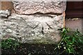
Old benchmark on jamb of building at Hall Bank
Ordnance Survey cut mark benchmark described on the Bench Mark Database at www.bench-marks.org.uk/bm67410. The mark was cut in 1855 as part of the Penrith to Workington survey line and levelled at 535.415 feet above Liverpool Datum. The surveyor's description was ' Mark on jamb of door of Mr. Redley's barn, at East end of Stainton Village'. The doorway is now a window.
Image: © Roger Templeman
Taken: 19 Feb 2020
0.12 miles