IMAGES TAKEN NEAR TO
The Drive, PENRITH, CA11 0AQ
Introduction
This page details the photographs taken nearby to The Drive, CA11 0AQ by members of the Geograph project.
The Geograph project started in 2005 with the aim of publishing, organising and preserving representative images for every square kilometre of Great Britain, Ireland and the Isle of Man.

There are currently over 7.5m images from over14,400 individuals and you can help contribute to the project by visiting https://www.geograph.org.uk
Image Map
Images are licensed for reuse under creativecommons.org/licenses/by-sa/2.0
Notes
- Clicking on the map will re-center to the selected point.
- The higher the marker number, the further away the image location is from the centre of the postcode.
Image Listing (38 Images Found)
Images are licensed for reuse under creativecommons.org/licenses/by-sa/2.0
Image
Details
Distance
1
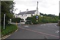
Newton Rigg College campus
See the grid square discussion for information on the history of the former Cumberland and Westmorland Agricultural College.
Image: © Richard Webb
Taken: 22 Jul 2019
0.01 miles
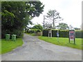
2
Car park entrance, Newton Rigg College
Image: © Karl and Ali
Taken: 12 Apr 2017
0.03 miles
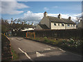
3
Entrance to Newton Rigg College
Newton Rigg College (in effect the Cumbria Agricultural College) is a devolved part of Askham Bryan College. This is not the main entrance and only gives vehicular access to a few houses, but is the way followed by the world-famous C2C cycle route. The notice board on the right gives details of connections to the other parts of the National Cycle Network.
Image: © Oliver Dixon
Taken: 21 Jul 2016
0.03 miles
4
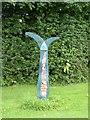
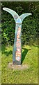
National Cycle Network milepost outside Newton Rigg College
The National Cycle Network is marked at intervals by specially designed mileposts donated to the project by the Royal Bank of Scotland. This example stands beside the world-famous C2C cycle route. There are four designs - one each by an Englishman, a Welshman, a Scotsman and an Irishman. The example seen here is an "English" one, entitled "the Fossil Tree" and designed by John Mills. The arms indicate Keswick 19 miles to the left; and Penrith 1 and Sunderland 60 miles to the right. This specimen has been colourfully enhanced - compare with Image
Image: © Oliver Dixon
Taken: 21 Jul 2016
0.04 miles
5
Royal Bank of Scotland milepost on NE side of road at Newton Rigg
On National Cycle Network route C2C
Image: © Luke Shaw
Taken: 8 Jul 2022
0.05 miles
6
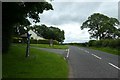
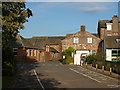
Road to Penrith
Looking along the road leading to Penrith from outside the college at Newton Rigg. The cycle route to Penrith is to the left, through the college.
Image: © DS Pugh
Taken: 11 Jul 2020
0.05 miles
7
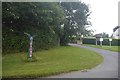
Millennium milepost, Newton Rigg College
Where the route leaves the road for the somewhat begrudged crossing of the campus of Newton Rigg College.
See the grid square discussion for information on the history of the former Cumberland and Westmorland Agricultural College.
Image: © Richard Webb
Taken: 22 Jul 2019
0.06 miles
8
Narrow field gateway on SW side of Newton Road
Ordnance Survey documents indicate that a rivet benchmark levelled at 162.190m above Newlyn Datum was verified in 1969 on the step between the gateposts
Image: © Roger Templeman
Taken: 8 Jul 2022
0.06 miles
9
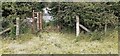
Cycle Path Newton Rigg College
The point where the cycle and footpath from Newton Road leads through between the buildings at Newton Rigg College.
Image: © Steve Houldsworth
Taken: 14 Oct 2011
0.06 miles
10
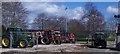
Tractor Park at Newton Rigg.
Even students have time to play with the sports facility in the background.
Image: © John Holmes
Taken: 29 Mar 2006
0.06 miles