IMAGES TAKEN NEAR TO
Tebay, PENRITH, CA10 3XX
Introduction
This page details the photographs taken nearby to CA10 3XX by members of the Geograph project.
The Geograph project started in 2005 with the aim of publishing, organising and preserving representative images for every square kilometre of Great Britain, Ireland and the Isle of Man.

There are currently over 7.5m images from over14,400 individuals and you can help contribute to the project by visiting https://www.geograph.org.uk
Image Map (Loading...)


Getting Data...Please wait
Leaflet Map data © OpenStreetMap
Images are licensed for reuse under creativecommons.org/licenses/by-sa/2.0
Notes
- Clicking on the map will re-center to the selected point.
- The higher the marker number, the further away the image location is from the centre of the postcode.
Image Listing (18 Images Found)
Images are licensed for reuse under creativecommons.org/licenses/by-sa/2.0
Image
Details
Distance
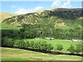
2
Railway and fields towards High Cargill
High Cargill Farm is the farm to be seen to the right
Image: © John Firth
Taken: 13 May 2011
0.06 miles
3
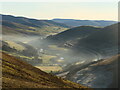
Temperature inversion in Lunedale
The fog has almost evaporated at this point but was still thick over Morecambe Bay and well to the south. The West Coast Main Line and M6 squeeze through the westernmost of the Yorkshire Dales, a narrow corridor between the Lake District National Park (foreground) and the Yorkshire Dales National Park over the river.
Image: © Richard Webb
Taken: 19 Dec 2021
0.07 miles
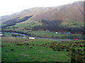
4
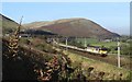
West Coast Mainline
A view in the Lune Gorge of a train coming south with Jeffrey's mount in the background.
Image: © Don Burgess
Taken: 23 Oct 2007
0.07 miles
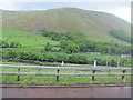
5
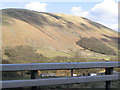
Blease Fell
Blease Fell, with High Carlingill below, taken from the M6 motorway.
Image: © Peter Craine
Taken: 10 Apr 2006
0.07 miles
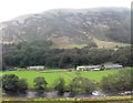
6
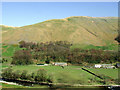
High Carlingill
With the River Lune in the foreground and Blease Fell in the background. Viewed from a Glasgow bound train.
Image: © Thomas Nugent
Taken: 18 Apr 2014
0.07 miles
7
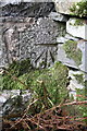
Benchmark on gatepost at entrance road to High Carlingill
Ordnance Survey cut mark benchmark described on the Bench Mark Database at http://www.bench-marks.org.uk/bm50937
Image: © Roger Templeman
Taken: 28 Aug 2013
0.08 miles
8
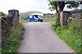
Anyone seen a river or lake?
The road from High Carlingill with an OS benchmark Image on the right hand side gatepost
Image: © Roger Templeman
Taken: 28 Aug 2013
0.09 miles