IMAGES TAKEN NEAR TO
Gaisgill, PENRITH, CA10 3UD
Introduction
This page details the photographs taken nearby to CA10 3UD by members of the Geograph project.
The Geograph project started in 2005 with the aim of publishing, organising and preserving representative images for every square kilometre of Great Britain, Ireland and the Isle of Man.

There are currently over 7.5m images from over14,400 individuals and you can help contribute to the project by visiting https://www.geograph.org.uk
Image Map
Images are licensed for reuse under creativecommons.org/licenses/by-sa/2.0
Notes
- Clicking on the map will re-center to the selected point.
- The higher the marker number, the further away the image location is from the centre of the postcode.
Image Listing (3 Images Found)
Images are licensed for reuse under creativecommons.org/licenses/by-sa/2.0
Image
Details
Distance
1
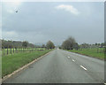
A685 east long straight stretch east of Gaisgill
Directly north of Longdale
Image: © John Firth
Taken: 14 May 2012
0.20 miles
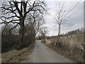
3
The walled lane past the sheep dip
The sheep dip is shown on the map but is hardly more worthy of naming than most sheep dips we have come across.
Image: © Karl and Ali
Taken: 10 May 2015
0.24 miles