IMAGES TAKEN NEAR TO
Cross Garth, PENRITH, CA10 3NN
Introduction
This page details the photographs taken nearby to Cross Garth, CA10 3NN by members of the Geograph project.
The Geograph project started in 2005 with the aim of publishing, organising and preserving representative images for every square kilometre of Great Britain, Ireland and the Isle of Man.

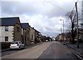
There are currently over 7.5m images from over14,400 individuals and you can help contribute to the project by visiting https://www.geograph.org.uk
Image Map
Images are licensed for reuse under creativecommons.org/licenses/by-sa/2.0
Notes
- Clicking on the map will re-center to the selected point.
- The higher the marker number, the further away the image location is from the centre of the postcode.
Image Listing (112 Images Found)
Images are licensed for reuse under creativecommons.org/licenses/by-sa/2.0
Image
Details
Distance
1
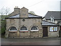
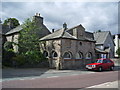
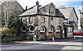
Shap Market House
The market was granted in 1687, so this building is c1690.
Image: © Martin Dawes
Taken: 17 May 2012
0.02 miles
2
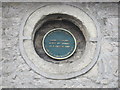
Plaque on Shap Market House
Set in one of the blocked up upper windows, and you have to stand in the middle of Main Street to read it.
Image: © Martin Dawes
Taken: 17 May 2012
0.02 miles
3
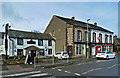
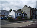
Businesses in Shap Village
I have childhood memories of traffic filing slowly through Shap on the A6. Considering the size of modern lorries and the current volume of traffic, coming through the village nowadays would be a nightmare without the M6.
Image: © Mary and Angus Hogg
Taken: 9 Mar 2020
0.02 miles
4
Shap Market Cross (Built 1687)
http://www.shapcumbria.co.uk
Image: © Alexander P Kapp
Taken: 2 Sep 2007
0.02 miles
5
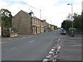
Main Street, Shap (A6)
In the past, prior to the opening of the M6, this was the main west coast route north and south. It was extremely busy and very slow going.
Image: © G Laird
Taken: 18 Sep 2013
0.03 miles
6
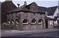
Shap Market Hall
Shap Market Hall was built around 1687, when a market charter obtained by Philip, Lord Wharton. The building is Grade II* listed, see:https://historicengland.org.uk/listing/the-list/list-entry/1145382
Image: © Philip Halling
Taken: 8 Jun 1991
0.03 miles
7
Market Cross on west side of Main Street
There is an Ordnance Survey benchmark which was levelled at 254.126m above Newlyn Datum in 1969 on the first pillar right of the near corner of the building. The mark is probably that levelled at 833.520 feet above Liverpool Datum during the 1841/4 L:iverpool to Port Carlisle 1GL Survey. The surveyor's description was 'No. 344. Mark on central pier of Old Market House, in Shap Village'
Image: © Roger Templeman
Taken: 28 Mar 2024
0.03 miles
9
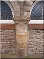
OS benchmark - Shap, Market Cross building
An OS cutmark on one of the pillars of the Image; originally levelled in 1969 at 254.126m above Ordnance Datum Newlyn.
Image: © Richard Law
Taken: 10 Apr 2014
0.03 miles