IMAGES TAKEN NEAR TO
Shap, PENRITH, CA10 3NE
Introduction
This page details the photographs taken nearby to CA10 3NE by members of the Geograph project.
The Geograph project started in 2005 with the aim of publishing, organising and preserving representative images for every square kilometre of Great Britain, Ireland and the Isle of Man.

There are currently over 7.5m images from over14,400 individuals and you can help contribute to the project by visiting https://www.geograph.org.uk
Image Map
Images are licensed for reuse under creativecommons.org/licenses/by-sa/2.0
Notes
- Clicking on the map will re-center to the selected point.
- The higher the marker number, the further away the image location is from the centre of the postcode.
Image Listing (16 Images Found)
Images are licensed for reuse under creativecommons.org/licenses/by-sa/2.0
Image
Details
Distance
2
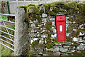
Victorian postbox, Wet Sleddale
Built into the wall by the entrance to Thorney Bank farm.
Image: © Jim Barton
Taken: 10 Oct 2009
0.03 miles
3
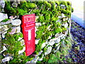
Red and Green
Víctorian postbox in mossy wall.
Image: © John H Darch
Taken: 6 Feb 2010
0.04 miles
4
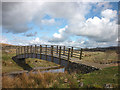
Footbridge, Cooper's Green
Over Wickers Gill
Image: © Mick Garratt
Taken: 29 Oct 2005
0.11 miles
5
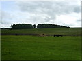
Pasture, Cooper's Green
Three Fell Ponies grazing near Cooper's Green
Image: © Michael Graham
Taken: 7 Jun 2009
0.15 miles
6
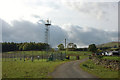
Weather station, Cooper's Green
An enclosure with 10m anemometer tower, thermometers, rain gauges and what I guess to be a visibility meter.
Image: © Jim Barton
Taken: 10 Oct 2009
0.15 miles
8
The River Lowther
The River Lowther in its infancy, near Wet Sleddale Reservoir.
Image: © James T M Towill
Taken: 30 Sep 2018
0.17 miles
9

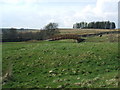
Access land and non-access land
The demarcation between land with open access and where there's not is clear to see in this image. The distant industrial installation is the Tata Steel limestone works near to Shap.
Image: © Trevor Littlewood
Taken: 13 Dec 2014
0.17 miles
10
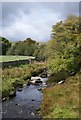
Footbridge, Cooper's Green
This elegant span over the infant River Lowther is just within the Lake District national park - unlike the four smoking stacks of the Tata limekilns in the distance!
Image: © Karl and Ali
Taken: 18 Mar 2012
0.17 miles