IMAGES TAKEN NEAR TO
Foster Street, PENRITH, CA10 3JT
Introduction
This page details the photographs taken nearby to Foster Street, CA10 3JT by members of the Geograph project.
The Geograph project started in 2005 with the aim of publishing, organising and preserving representative images for every square kilometre of Great Britain, Ireland and the Isle of Man.

There are currently over 7.5m images from over14,400 individuals and you can help contribute to the project by visiting https://www.geograph.org.uk
Image Map
Images are licensed for reuse under creativecommons.org/licenses/by-sa/2.0
Notes
- Clicking on the map will re-center to the selected point.
- The higher the marker number, the further away the image location is from the centre of the postcode.
Image Listing (101 Images Found)
Images are licensed for reuse under creativecommons.org/licenses/by-sa/2.0
Image
Details
Distance
1
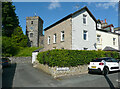
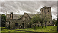
The end of Church Terrace, Shap
The church is up on the hill behind.
Image: © Humphrey Bolton
Taken: 5 Jul 2021
0.03 miles
3
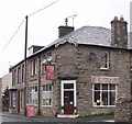
Cream 17, coffee shop, Shap
A friendly local cafe with good food and drink.
Image: © nick macneill
Taken: 2 Sep 2011
0.04 miles
4
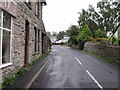
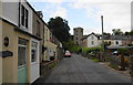
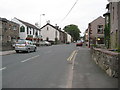
Main Street, Shap
The A6, now quiet thanks to the motorway.
Image: © Humphrey Bolton
Taken: 5 Jul 2021
0.04 miles
5
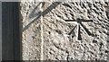
Ordnance Survey 1GL Bolt
This OS Bolt can be found on the west face of St Michael's Church. It marks a point 263.149m above mean sea level.
Image: © Adrian Dust
Taken: 12 Sep 2018
0.04 miles
6
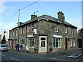
Abbey Coffee Shop, Shap
On Main Street (A6).
Image: © JThomas
Taken: 22 Oct 2016
0.05 miles
8
Church Street, Shap
St Michael's Church is raised up at the end of the street.
Image: © Bill Boaden
Taken: 23 Jul 2010
0.05 miles
9
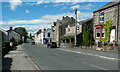
Shap
Before the construction of the M6 motorway the A6 through Shap was one of the main roads to Scotland.
Image: © Philip Halling
Taken: 29 Aug 2008
0.05 miles
10
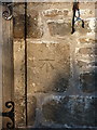
OS bolt & benchmark - Shap, St Michael's Church
An OS bolt and cutmark, dating from the First Primary Levelling survey in the early 1840s; and levelled at almost exactly 863 feet above Liverpool Datum. It's now considered to be 263.149m above Newlyn Datum.
Image: © Richard Law
Taken: 20 Apr 2016
0.05 miles