IMAGES TAKEN NEAR TO
Maulds Meaburn, PENRITH, CA10 3HN
Introduction
This page details the photographs taken nearby to CA10 3HN by members of the Geograph project.
The Geograph project started in 2005 with the aim of publishing, organising and preserving representative images for every square kilometre of Great Britain, Ireland and the Isle of Man.

There are currently over 7.5m images from over14,400 individuals and you can help contribute to the project by visiting https://www.geograph.org.uk
Image Map
Images are licensed for reuse under creativecommons.org/licenses/by-sa/2.0
Notes
- Clicking on the map will re-center to the selected point.
- The higher the marker number, the further away the image location is from the centre of the postcode.
Image Listing (39 Images Found)
Images are licensed for reuse under creativecommons.org/licenses/by-sa/2.0
Image
Details
Distance
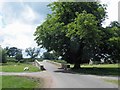
1
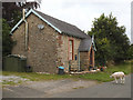
Maulds Meaburn: former Methodist chapel
The chapel was built in 1878 but at some time has closed and is now a private house. Several sheep, both black and white, roam the village, not bothered by either pedestrians or occasional motor traffic.
Image: © Stephen Craven
Taken: 3 Aug 2019
0.01 miles
2
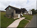
Maulds Meaburn: bus shelter and former police station
The stone shelter doubles as a village information point. The logo of the Yorkshire Dales National Park on the gable end suggests they may have paid for it. The white building in the background is the former police station, built 1864 and in use until the 1970s.
Image: © Stephen Craven
Taken: 3 Aug 2019
0.03 miles
3
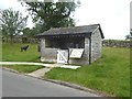
Bus shelter, Maulds Meaburn
Catering for travellers on the once-weekly bus to Penrith (on a Tuesday if you must know). Whilst waiting, intending passengers can study the numerous village notices posted inside. Between times, please shut the gate to keep out the sheep which roam freely over the large village green.
Image: © Oliver Dixon
Taken: 2 Aug 2019
0.03 miles
4
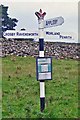
Old Direction Sign - Signpost in Maulds Meaburn, Crosby Ravensworth parish
Crown finial - 3 arms; Westmorland crown by the UC road, in parish of Crosby Ravensworth (Eden District), Maulds Meaburn.
Surveyed
Milestone Society National ID: WE_NY6216
Image: © Milestone Society
Taken: Unknown
0.03 miles
5
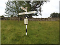
Maulds Meaburn: road sign by the upper bridge
The directions sign points to Crosby Ravensworth; Appleby; and Morland and Penrith. Note the crown atop the post, perhaps a reference to the adjacent village of King's Meaburn.
Image: © Stephen Craven
Taken: 3 Aug 2019
0.03 miles
6
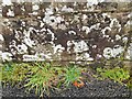
Ordnance Survey Cut Mark
This OS cut mark can be found on the north parapet of the bridge. It marks a point 171.738m above mean sea level.
Image: © Adrian Dust
Taken: 27 Oct 2023
0.04 miles
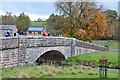
7
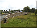
Maulds Meaburn: upper bridge
One of two stone road bridges across the river Lyvennet in the village built in the 1860s. See Image for the "low bridge".
Image: © Stephen Craven
Taken: 3 Aug 2019
0.04 miles
8
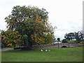
Bridge and chestnut tree, Maulds Meaburn
It's August Bank Holiday but already autumn is showing the first signs of its inevitable arrival.
Image: © Karl and Ali
Taken: 28 Aug 2011
0.04 miles
10
Bridge over the Lyvennet, Maulds Meaburn
One of two road bridges in the village over the River Lyvennet, a tributary of the Eden.
Image: © Jim Barton
Taken: 22 Oct 2014
0.05 miles