IMAGES TAKEN NEAR TO
Burnbanks, PENRITH, CA10 2RW
Introduction
This page details the photographs taken nearby to CA10 2RW by members of the Geograph project.
The Geograph project started in 2005 with the aim of publishing, organising and preserving representative images for every square kilometre of Great Britain, Ireland and the Isle of Man.

There are currently over 7.5m images from over14,400 individuals and you can help contribute to the project by visiting https://www.geograph.org.uk
Image Map
Images are licensed for reuse under creativecommons.org/licenses/by-sa/2.0
Notes
- Clicking on the map will re-center to the selected point.
- The higher the marker number, the further away the image location is from the centre of the postcode.
Image Listing (43 Images Found)
Images are licensed for reuse under creativecommons.org/licenses/by-sa/2.0
Image
Details
Distance
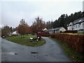
1
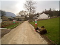
Burnbanks
A village underneath The Haweswater Dam
Image: © Nigel Homer
Taken: 11 Feb 2006
0.01 miles
2
Burnbanks
A village of concrete houses built for the construction workers of the dam. These are now being renovated for sale to local people.
Image: © Mick Garratt
Taken: 28 Oct 2005
0.01 miles
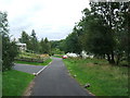
3
Village green, Burnbanks
The construction of the dam and associated works at Haweswater throughout the 1930s required a large labour force which could not be sourced locally. Instead of a "navvy camp", Manchester corporation built a model village of 66 self-contained bungalows.
Latterly, the remaining bungalows have been rebuilt and sold to private owners.
Image: © Oliver Dixon
Taken: 29 Nov 2008
0.02 miles
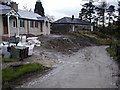
4
Burnbanks rebuilt
The construction of the dam and associated works at Haweswater throughout the 1930s required a large labour force which could not be sourced locally. Instead of a "navvy camp", Manchester corporation built a model village of 66 self-contained bungalows.
Latterly, the remaining bungalows have been rebuilt and sold to private owners - and they are not cheap!
Image: © Oliver Dixon
Taken: 29 Nov 2008
0.02 miles
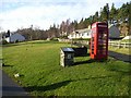
5
Burnbanks village
The telephone box contains a phone...something of a rarity these days
Image: © David Brown
Taken: 15 Nov 2021
0.02 miles
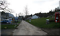
8
Houses in Burnbanks
Burnbanks is a small village close to the Haweswater dam. The settlement was created to house workers and their families who were part of the construction team building the dam to confine the reservoir, in the 1930's.
Image: © Trevor Littlewood
Taken: 23 Jun 2016
0.03 miles
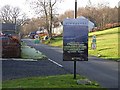
9
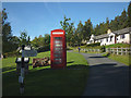
Red telephone box, Burnbanks
Things looked different since our last visit, probably more than ten years ago. It appears that the hamlet has had a face lift Image since then.
Image: © Karl and Ali
Taken: 7 Oct 2012
0.03 miles
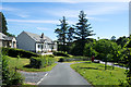
10
Bungalows at Burnbanks
The construction of the dam and associated works at Haweswater throughout the 1930s required a large labour force which could not be sourced locally. Instead of a "navvy camp", Manchester corporation built a model village of 66 self-contained bungalows.
Latterly, the remaining bungalows have been rebuilt and sold to private owners.
Image: © Oliver Dixon
Taken: 29 Nov 2008
0.03 miles