IMAGES TAKEN NEAR TO
Bampton, PENRITH, CA10 2RJ
Introduction
This page details the photographs taken nearby to CA10 2RJ by members of the Geograph project.
The Geograph project started in 2005 with the aim of publishing, organising and preserving representative images for every square kilometre of Great Britain, Ireland and the Isle of Man.

There are currently over 7.5m images from over14,400 individuals and you can help contribute to the project by visiting https://www.geograph.org.uk
Image Map
Images are licensed for reuse under creativecommons.org/licenses/by-sa/2.0
Notes
- Clicking on the map will re-center to the selected point.
- The higher the marker number, the further away the image location is from the centre of the postcode.
Image Listing (8 Images Found)
Images are licensed for reuse under creativecommons.org/licenses/by-sa/2.0
Image
Details
Distance
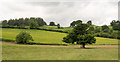
3
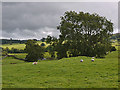
Field and trees near Walmgate farm
Sheep enjoy a splash of sun, while drizzle rules beyond.
Image: © Nigel Brown
Taken: 19 Sep 2013
0.13 miles
4
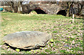
A Big Stone
A big stone near Haweswater Beck
Image: © William England
Taken: 31 Mar 2009
0.20 miles
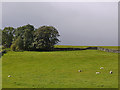
5
Trees and fields near Haweswater Beck
Haweswater Beck, (which carries away the water from Haweswater not required by Manchester), lies to the east of the fields seen here - to the right, out of the image.
Image: © Trevor Littlewood
Taken: 24 Jun 2016
0.23 miles
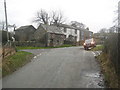
6
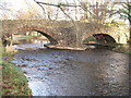
Bridge over Haweswater Beck at Greengate.
Looking NW.
Image: © Steve Partridge
Taken: 19 Dec 2005
0.23 miles
7
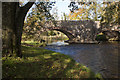
The bridge over Haweswater Beck at Greengate
Image: © Ian Greig
Taken: 28 Oct 2011
0.25 miles
8
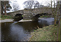
Halfa Bridge
Over Haweswater Beck. Looking upstream. See http://list.english-heritage.org.uk/resultsingle.aspx?uid=1121874.
Image: © Ian Taylor
Taken: 31 Mar 2014
0.25 miles