IMAGES TAKEN NEAR TO
Bampton, PENRITH, CA10 2QZ
Introduction
This page details the photographs taken nearby to CA10 2QZ by members of the Geograph project.
The Geograph project started in 2005 with the aim of publishing, organising and preserving representative images for every square kilometre of Great Britain, Ireland and the Isle of Man.

There are currently over 7.5m images from over14,400 individuals and you can help contribute to the project by visiting https://www.geograph.org.uk
Image Map
Images are licensed for reuse under creativecommons.org/licenses/by-sa/2.0
Notes
- Clicking on the map will re-center to the selected point.
- The higher the marker number, the further away the image location is from the centre of the postcode.
Image Listing (5 Images Found)
Images are licensed for reuse under creativecommons.org/licenses/by-sa/2.0
Image
Details
Distance
2
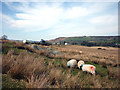
Sheep grazing near Rosgill
The limestone scarp of Knipe Scar rises above the settlement of Toathmain.
Image: © Karl and Ali
Taken: 10 Apr 2010
0.13 miles
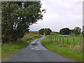
5
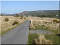
The road from Swindale
The road descends to the Lowther valley. The houses at Toathmain can be seen in the middle distance.
Image: © Oliver Dixon
Taken: 12 Apr 2019
0.22 miles