IMAGES TAKEN NEAR TO
Temple Sowerby, PENRITH, CA10 2AN
Introduction
This page details the photographs taken nearby to CA10 2AN by members of the Geograph project.
The Geograph project started in 2005 with the aim of publishing, organising and preserving representative images for every square kilometre of Great Britain, Ireland and the Isle of Man.

There are currently over 7.5m images from over14,400 individuals and you can help contribute to the project by visiting https://www.geograph.org.uk
Image Map
Images are licensed for reuse under creativecommons.org/licenses/by-sa/2.0
Notes
- Clicking on the map will re-center to the selected point.
- The higher the marker number, the further away the image location is from the centre of the postcode.
Image Listing (14 Images Found)
Images are licensed for reuse under creativecommons.org/licenses/by-sa/2.0
Image
Details
Distance
1
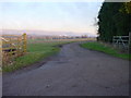
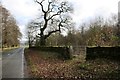
Bridleway and Farm Entrance
Leads to Ash Hill, overlooking the Eden Valley.
Image: © Bob Jenkins
Taken: 28 Jan 2006
0.04 miles
2
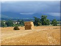
Farmland, Brougham
Harvested fields at Ash Hill with a view across the Eden valley towards the Pennines.
Image: © Andrew Smith
Taken: 7 Sep 2012
0.08 miles
3
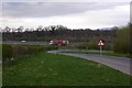
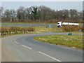
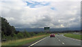
The road over Winfell meets the A66
A dual carriageway bit of the A66.
Image: © Richard Webb
Taken: 4 Apr 2019
0.09 miles
4
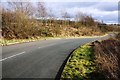
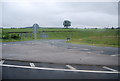
Road linking Ash Hill Cottges and Whinfell House to A66
This road replaced a direct road from Ash Hill cottages to what is now the B6412 when the A66 was built. Ordnance Survey records indicate that there was a wall along the SE side of the original road which had a benchmark in 1972. See www.bench-marks.org.uk/bm115937
Image: © Luke Shaw
Taken: 4 Feb 2020
0.14 miles
5
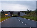
Western end of the Temple Sowerby Bypass
The Temple Sowerby by-pass was opened in 2007, allowing traffic along the busy A66 to by-pass the village. The minor road in the foreground is the road from Cliburn and there are exits from and ways on to both carriageways of the by-pass.The blue signage indicates a slightly shorter route for cyclists bound for Penrith to join the main road. But any cyclist following the signs should beware. 300 metres to the west of this point, the separate cycle track merges with the main traffic onto a 7 km length of very busy fast single carriageway road all the way to Penrith - massive irresponsibility on the part of the Highway Agency.
Image: © Oliver Dixon
Taken: 18 Mar 2015
0.15 miles
7
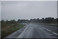
Road bridge
Turn right Cliburn and straight on and round to the left for the A66. The bridge carries the western end of the Temple Sowerby By-pass over the minor road too Cliburn
Image: © Alexander P Kapp
Taken: 13 Sep 2011
0.15 miles
9
Start of Temple Sowerby by pass
A66 east
Image: © John Firth
Taken: 29 Jul 2012
0.16 miles
10
Field gateway from B6412 opposite junction to Winderwath
Ordnance Survey records indicate that in 1972 there was a benchmark on a stone gatepost at this gateway; see www.bench-marks.org.uk/bm115994. There are now wooden posts.
Image: © Luke Shaw
Taken: 4 Feb 2020
0.21 miles